Trip
Hiking – Argentine Peak
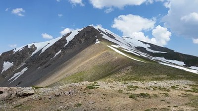
From the NW ridge we'll gain Argentine Pass and then the peak. The TH is found on Peru Creek Rd. If the weather cooperates, 360 degree views will be available. This is a strenuous and beautiful workout.
Contacts

- Wed, Sep 30, 2026
- Bobcats Section
- Hiking
- Adults, All Who Qualify
- Challenging
- Mileage: 7.5 mi
- Elevation Gain: 3,000 ft
- High Point Elevation: 13,743 ft
- Maximum Wind: 20 kts
- Pace: 1.5 - 1.7 mph moving pace
- FULL, 1 on waitlist (6 capacity)
- 1 (2 capacity)
- Fri, Sep 25, 2026 at 9:30 AM
- Mon, Sep 28, 2026 at 5:00 PM
- Cancellation & Refund Policy
This hike will take about 5.5 to 6 hrs.
The trail up to Argentine Pass is a long, gorgeous traverse with a steady incline and beautiful vistas. After reaching the pass, turn right. There are vague glimpses of a trail to the peak. Stay to the ridge and follow the trail. There are four false summits or "bumps". As we reach the top of one, only to see the next down and up. It's a really great hike all on its. The pass was formerly used by a toll road and stagecoach route. The trail on the west side of the pass is the remains of this road. To the east, the Argentine Central Railway ran from Georgetown to the pass from 1906 to 1918. The Jeep trail (on the East side) to the pass follows the grade of this abandoned railroad. Argentine Pass is the highest pass on the Continental Divide.
Wooly Mammoth, section BB at 6:30 am
Hoping to have 1 additional higher clearance vehicle in addition to my truck that seats 5.
https://maps.app.goo.gl/FX3urJQ5vLfnb2BcA
Coming from Loveland Pass and /or A-Basin, you will have to go past this exit, turn around at the first possible opportunity (Gondola Road for Keystone), then drive back east to the exit. Measure distances from the stop sign once you exit. The Montezuma road goes briefly south, passing by some of the parking for the ski area, then heads east and follows along the Snake River. At about 4.3 miles from the turn off from US 6, watch for the road to make a sharper left, then right turn. At that right hand turn, make a left turn onto FR 260. This is the Peru Creek Road. There is a large staging/parking area here. Coordinates for the turnoff are: N 39° 35' 31.28" W 105° 52' 15.66". In 2021, there were no clearance issues, just a lot of shallow potholes to slow you down. Certainly, most modern SUV type vehicles, like Honda's, Subaru's etc. could make this drive. Along the first mile, In 1.0 mile, the road crosses Peru Creek. At 1.6 miles is the Lewanee TH. At 2.1 miles is the turnoff for Warden Gulch. The road makes a low-water crossing of Peru Creek. Continuing on the main Peru Creek road, at 2.2 miles is the turnoff for Chihuahua Gulch.
Continuing on the main Peru Creek road, after the turnoff for Cinnamon Gulch, the road deteriorates and becomes more rocky, but still, carefully driven SUV's with better clearance may be able to continue all the way to roads end near the parking area at the Shoe Basin Mine. This is the Ruby Mtn. trailhead. Shortly beyond here, the road is usually gated. The main coordinates posted for trailhead on this page are for this upper access to Ruby.
Required Equipment
10 essentials and poles can be helpful for descending on the ridge rocks.