Trip
Hiking – Mt Silverheels
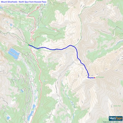
From the parking area at Hoosier Pass we'll cross the road to start from the East side. Briefly hike up a road, then up an informal trail as you climb Hoosier Ridge. After a little over two miles of hiking (when the ridge heads to the north), we will leave Hoosier Ridge and descend about 400' to the north spur of Mt Silverheels. From there, we will climb up the spur to the summit. Most of the hike is above 12,000' and off trail, so the views are fantastic but there are a lot of high altitude up and downs.
Contacts

- Wed, Sep 30, 2026
- Bobcats Section
- Hiking
- Basic Alpine Climb
- Adults
- Difficult
- Mileage: 9.0 mi
- Elevation Gain: 3,500 ft
- High Point Elevation: 13,823 ft
- Pace: 1.7 - 2.0 mph
- 6 (6 capacity)
- 1 (2 capacity)
- Cancellation & Refund Policy
Silverheels is a high 13er and harder than some 14ers. Only sign up for this hike if you're confident you can hike above 11,000' at 1.7 - 2.0 mph average pace with the large 3500ft elevation gain. The hike is mostly above treeline so we will target finishing before 1pm.
Hiking poles are highly recommended for this hike.
We will meet at the 285 and Twin Forks Park and Ride and then carpool (or you can meet us at the Hoosier Pass parking area). Meet time 5:15 am.
We will plan on starting the hike about 6:45 am.
Mileage is 148 RT miles (x$.40 = $60 divided by # of hikers in car). Trip should take 90 mins.
Link to route -
https://www.14ers.com/route.php?route=201201050806033 https://www.alltrails.com/trail/us/colorado/mount-silverheels
Required Equipment
10 essentials. Carry poles even if you keep them in your pack. Paper map for navigating.