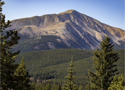
Mt Silverheels
Mt Silverheels (13,829') is located near Hoosier Pass and Alma, CO.
For further information see: Mount Silverheels : Climbing, Hiking & Mountaineering : SummitPost and 14'ers.com.
Alternate Titles:
Mt Silverheels via Hoosier Ridge: Start across the road from the parking area at Hoosier Pass. Briefly hike up a road, then up an informal trail as you climb Hoosier Ridge. After a little over two miles of hiking (when the ridge heads to the north), leave Hoosier Ridge and descend about 400' to the north spur of Mt Silverheels. From there, climb up the spur to the summit. Most of the hike is above 12,000' with a lot of high altitude up and downs. 9 miles, 3500' gain
Mt. Silverheels via Tarryall Creek Trailhead: Begin at Gold Dust Trailhead, follow the Gold Dust Trail (USFS #698) south, then ascend the Trout Creek Trail (USFS #614) and mountain's northeast ridge. 9.4 miles, 3,800' gain
- Suitable Activities: Hiking, Mountaineering, Scrambling, Snowshoeing
- Snowshoeing Category: Intermediate
- Seasons: July, August, September, October
- Weather: View weather forecast
- View avalanche forecast.
- 13,822 ft
-
Land Manager:
U.S. Forest Service
South Park Ranger District (PSINF)
- Parking Permit Required: USFS Permits & Passes
- Recommended Party Size: 12
- Maximum Party Size: 15
- Maximum Route/Place Capacity: 15
- SummitPost
- 14ers.com
- CoTrex
- AllTrails
- Peakbagger.com
This is a list of titles that represent the variations of trips you can take at this route/place. This includes side trips, extensions and peak combinations. Not seeing a title that fits your trip? Log in and send us updates, images, or resources.
- Mt Silverheels via Hoosier Ridge
- Mt Silverheels via Tarryall Creek TH
There are no resources for this route/place. Log in and send us updates, images, or resources.
