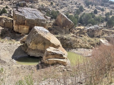
Apishapa Canyon State Wildlife Area
Hike into a remote and scenic series of canyons about 25 mi. east of Walsenburg, CO. The area is mainly pinion-juniper woodland, grassland and riparian habitat. Deer, antelope, and bighorn sheep, as well as birds such as rock and canyon wrens, and canyon towhee are reported.
From Walsenburg take I-25 to CO 10, go east 18.5 miles, then south on CR 210/77 and follow signs to Apishapa State Wildlife Area south entrance. The trip starting point is along a two-track road approximately 2 1/2 miles NE of the south entrance to Apishapa Canyon State Wildlife Area at lon/lat -104.25126, 37.63748 degrees. From there, hike along an old road east then north to its end. Follow a fence line about 500 feet, and then follow the ridge descending 375 feet into the canyon along a faint old road. This is a somewhat rocky Class 2 descent. From there, continue as far as desired, up to the SWA boundary. From the identified start point to the boundary is about 9 miles RT, 1100' elevation gain. A short side trip up Jones Lake Canyon is optional. Various other access points are possible, however scrambling may be required.
A valid hunting or fishing license or State Wildlife Area pass is required for everyone 16 or older. Public access is prohibited from June 1 through August 15. Most road surfaces are likely to be impassable when wet and marked as "Closed when muddy".
See https://cpw.state.co.us/sites/default/files/dam/x4cyohgtfj/apishapaswa_geo.pdf for maps and more information.
- Suitable Activities: Hiking
- Seasons: January, February, March, April, May, September, October, November, December
- Weather: View weather forecast
- Length: 9.0 mi
- Elevation Gain: 1,100 ft
- 5,085 ft
- Land Manager: Colorado State Wildlife Area
- Parking Permit Required: State Wildlife Area Pass
- Recommended Party Size: 12
- Maximum Party Size: 12
- Maximum Route/Place Capacity: 12
- CalTopo
- COTREX
There are no resources for this route/place. Log in and send us updates, images, or resources.