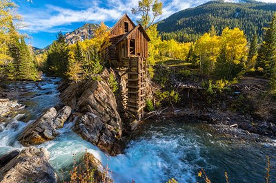
Crystal Mill
This out-n-back hike (~8 miles, ~1000 ft elevation gain) follows a rugged mountain road along the Crystal River near Marble, into a steep, glacially carved alpine valley to the iconic Crystal Mill, one of Colorado’s most photographed historic mining structures.
This out-n-back hike follows roughly 8 miles round trip with about 1000 feet of elevation gain along a rugged 4WD road that traces the Crystal River into a narrow, glacially carved alpine valley leading to the iconic Crystal Mill. The route travels primarily on a rough 4WD road with steady elevation gain and occasional creekside exposure, ending at the 1890s-era wooden power plant built to serve the silver mining operations of the former town of Crystal. (Crystal Mill | COTREX)
Note - Private Ownership: The mill itself is private property. Visitors can hike or drive to it, but accessing the riverside or taking photos up close usually requires paying a small fee (typically $10 to $20) and signing a waiver.
At the turnaround point sits the Crystal Mill, a dramatically perched wooden powerhouse that reflects the engineering ambition of Colorado’s silver-mining era in a highly constrained mountain landscape. Built in the early 1890's by the Sheep Mountain Tunnel and Mining Company, it operated as a compressed-air facility supporting nearby mining operations during the region’s boom before being abandoned as the industry declined. Today, it remains one of the most recognizable relics of Colorado’s mining heritage, illustrating both the ingenuity and impermanence of high-alpine industrial development.
Alternate Title - Lead King Basin/Crystal Mill Loop - ~12.5 miles, ~2600' gain
- Suitable Activities: Backcountry Nordic Skiing, Hiking, Snowshoeing
- Snowshoeing Category: Intermediate
- Seasons: Year-round
- Weather: View weather forecast
- Avalanche Terrain Rating Complex View avalanche forecast.
- Length: 8.0 mi
- Elevation Gain: 100 ft
- 8,930 ft
-
Land Manager:
U.S. Forest Service
Gunnison Ranger District (GMUG)
- Parking Permit Required: USFS Permits & Passes
- Recommended Party Size: 10
- Maximum Party Size: 12
- Maximum Route/Place Capacity: 12
- gaia gps
- trails illistrated 129
- CalTopo
- CoTrex
This is a list of titles that represent the variations of trips you can take at this route/place. This includes side trips, extensions and peak combinations. Not seeing a title that fits your trip? Log in and send us updates, images, or resources.
- Crystal Mill - Lead King Basin/Crystal Mill Loop
There are no resources for this route/place. Log in and send us updates, images, or resources.