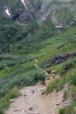
Ice Lake Basin Trailhead
Access to high alpine lakes such as Ice, Island, and Fuller Lakes outside of Silverton.
Ice Lake Basin TH is located at South Mineral Campground, which has restrooms. The TH is at 9843' elevation. The large basin is surrounded by 13'ers. The trek up to Ice Lake is short and steep, but not technical. The other lakes are reached off-trail either from the TH or from Ice Lake.
Alternate Titles:
Ice Lake #505 - 7 miles, 2500' gain, high point 12,300'
Island Lake - 9 miles, 2600' gain, high point 12,500'
Fuller Lake - is higher, at 12,600.' From the TH. 9.2 miles 2800' gain, high point 12,600 '
Clear Lake - reach by Clear Lake Road #815 - 4.4 miles, 2200' gain, high point 12,000'
- Suitable Activities: Backpacking, Hiking
- Seasons: June, July, August, September, October
- Weather: View weather forecast
- View avalanche forecast.
- 12,600 ft
-
Land Manager:
U.S. Forest Service
Columbine Ranger District (SJNF)
- Parking Permit Required: USFS Permits & Passes
- Recommended Party Size: 12
- Maximum Party Size: 12
- Maximum Route/Place Capacity: 15
- CoTrex
This is a list of titles that represent the variations of trips you can take at this route/place. This includes side trips, extensions and peak combinations. Not seeing a title that fits your trip? Log in and send us updates, images, or resources.
- Ice Lake Basin TH - Island Lake
- Ice Lake Basin TH - Ice Lake
- Ice Lake Basin TH - Fuller Lake
- Ice Lake Basin TH - Clear Lake
There are no resources for this route/place. Log in and send us updates, images, or resources.