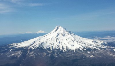
Mount Hood
Mt. Hood is Oregon's tallest peak and is one of the most popular alpine summits in the world. This iconic mountain lies 70 miles east of Portland and is part of the Cascade Range. Glaciers lie on all sides.
Mt Hood (11, 240') is considered a dormant (sleeping) volcano, with its last minor eruption in 1866. It features 12 named glaciers and active steam vents near its peak. It is located within the Mt Hood Wilderness.
Summit Post describes 20 routes up and around the mountain. This most common hike up is the Timberline Trail - 7.1 miles, 5400' gain.
Mount Hood is primarily managed by the Zig-Zag Ranger District (which covers the south and west slopes) and the Hood River Ranger District (which covers the north and east slopes). Both districts are part of the Mt. Hood National Forest in Oregon. Check the Forest Service page for permits, climbing conditions, and mountain/road alerts. You can email them at SM.FS.climb_mthood@usda.gov.
The 1.1-million-acre Mt. Hood National Forest features roughly 80 campgrounds, lodging, miles of trails and pristine lakes. A google search provides many local resources and recreation guides. Mt Hood Territory provides a comprehensive guide to lodging, camping, and the greater area.
- Suitable Activities: Mountaineering
- Climbing Category: Intermediate Alpine Climb
- Seasons: Year-round
- Weather: View weather forecast
- View avalanche forecast.
- Length: 6.0 mi
- Elevation Gain: 5,400 ft
- 11,220 ft
- Land Manager: U.S. Forest Service
- Parking Permit Required: USFS Permits & Passes
- Recommended Party Size: 3
- Maximum Party Size: 12
- Maximum Route/Place Capacity: 12
- SummitPost
- AllTrails
There are no resources for this route/place. Log in and send us updates, images, or resources.