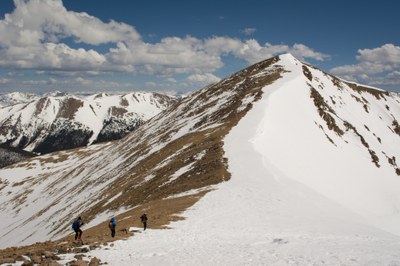
Mount Sniktau
Mount Sniktau is the 448th highest peak in Colorado located in Arapaho National Forest. Easy Class 2.
Mt Sniktau is an iconic must-do peak for CMC hikers. The typical route starts at the east side of Loveland Pass but other routes also are available. Always windy, with big cornices on either side of the trail well into summer.
Mount Sniktau is an easy Class 2 (barely - call it Class 1 with just a little Class 2 thrown in). When rock-hopping, be sure to look ahead to make sure you know where the trail picks up again on the other side of the rock piles.
Sniktau combines easily with UN13,117 (Cupid) and Grizzly Peak
USGS Quad: Grays Peak
Planning Map: Trails Illustrated #104 Idaho Springs | Georgetown | Loveland Pass
- Suitable Activities: Backcountry Skiing/Splitboarding, Hiking, Ski Mountaineering, Snowshoeing
- Seasons: Year-round
- Weather: View weather forecast
- Difficulty: Mod B
- Length: 3.9 mi
- Elevation Gain: 1,700 ft
- 13,216 ft
-
Land Manager:
U.S. Forest Service
Clear Creek Ranger District (ARNF)
- Parking Permit Required: USFS Permits & Passes
- Recommended Party Size: 12
- Maximum Party Size: 12
- Maximum Route/Place Capacity: 12
- CoTrex
- 14ers.com
- climb13ers.com
- Alltrails
This is a list of titles that represent the variations of trips you can take at this route/place. This includes side trips, extensions and peak combinations. Not seeing a title that fits your trip? Log in and send us updates, images, or resources.
- Mt Sniktau - UN13,117 (Cupid), and Grizzly Peak
- Mt Sniktau - from Bakerville
- Mt Sniktau - via Loveland Pass
There are no resources for this route/place. Log in and send us updates, images, or resources.