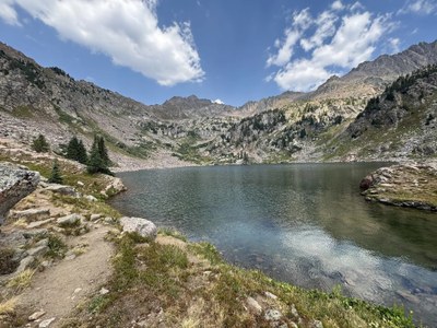
Pitkin Lake
The hike to Pitkin Lake in the Eagles Nest Wilderness is one of the most scenic in the Vail area. The long and steep trail runs west of Pitkin Creek for 9.9 miles to reach lovely Pitkin Lake just below timberline in a rocky bowl.
Begin the hike north from the Pitkin Trailhead sign and quickly cross Pitkin Creek and ascend steeply. Within 1 mile the grade becomes more gradual. After 2.5 miles, Lower Pitkin Falls is visible on the right (east). Continue up through a series of rocky benches and lush meadows to finally reach Pitkin Lake at the head of the valley. The nearby peaks are part of the Gore Range. The imposing peak to the north-northwest is called West Partner. The equally formidable peak the northeast is called East Partner. The lake is named after Frederick Pitkin who was a Colorado governor between 1879 and 1883.
- Suitable Activities: Hiking
- Seasons: June, July, August, September, October
- Weather: View weather forecast
- View avalanche forecast.
- Length: 9.9 mi
- Elevation Gain: 2,900 ft
- 11,380 ft
-
Land Manager:
Eagle County
Eagles Nest Wilderness Area, Eagle-Holy Cross Ranger District (WRNF)
- Parking Permit Required: Other
- Recommended Party Size: 12
- Maximum Party Size: 12
- Maximum Route/Place Capacity: 12
- National Geographic Map 108
- CoTrex
- AllTrails
There are no resources for this route/place. Log in and send us updates, images, or resources.