Trip
Hiking – Castlewood Canyon - Westside Trailhead
A double loop hike along the canyon floor as well as the canyon rim in the West side of the State Park.
- Wed, May 1, 2024
- Rocky Mountain Over the Hill Gang
- Hiking
- Adults
- Moderate
- Moderate
- Mileage: 8.1 mi
- Elevation Gain: 1,100 ft
- High Point Elevation: 6,600 ft
- Pace: Moderate (1.8 - 2.0 avg moving speed)
- 5 (8 capacity)
- FULL (2 capacity)
- Cancellation & Refund Policy
This hike is for RMOTHG members only
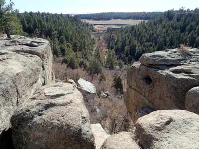
This hike has two loops. From the Westside Trailhead, we will first take a walk along the climbing wall, then we will follow the Creek Bottom Trail to the Dam Ruins. From there we will do a loop by hiking up the Lake Gulch Trail, then following the Inner Canyon Trail back to near the dam ruins. Then we will take the Rim Rock trail up to and along the rim on the east side of the canyon, then follow the Creek Bottom Trail back to the Westside Trailhead completing the second loop of the hike.
This hike is mostly on good trail, but there are several sections that are up and down wooden steps and some steeper rock steps. The Rimrock trail is mostly on hard rock surfaces. The hike along the Climbers Wall is on uneven trail.
We will meet at 8:30am in the Cabelas parking lot at Ridgegate and I-25 in Lone Tree, specifically in the northwest section of the parking lot close to Cabela's, for a prompt 8:45am departure. Here is a Google Maps link to Cabelas: https://goo.gl/maps/wWCXBUwvW7D5SDSg6. DO NOT PARK in the parking lot close to the Sierra Restaurant or the hotel!
We will be hiking from the Westside Trailhead in Castlewood Canyon State Park. The Westside Trailhead is about a mile past the Castlewood Canyon State Park's West Entrance on Castlewood Canyon Road. Here is a Google Maps link to the Westside Trailhead: https://maps.app.goo.gl/UAdMA4evVqYiTytT8
Required Equipment
Please bring your 10 essentials
