Trip
Hiking – Grand Mesa - Crater Peak
Hike through meadows and spruce to Grand Mesa's high point. 360 degree views!
- Fri, Jun 27, 2025
- Western Slope
- Hiking
- Adults
- Moderate
- Mileage: 8.0 mi
- Elevation Gain: 1,800 ft
- High Point Elevation: 11,333 ft
- Pace: 2
- 8 (11 capacity)
- Cancellation & Refund Policy
Most of this hike is a pleasant stroll through upland meadows and scattered spruce groves, following Goodenough Reservoir Road, a seldom used access road. The final 1.5 miles from the reservoir to the summit is off trail, but generally class two terrain. The final few feet to the summit involves boulder hopping.
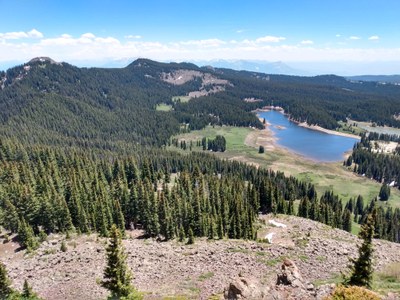
(I haven't hiked the final portion yet, but I've been up neighboring Mt Hatten. Photo shows Goodenough Reservoir with Crater Peak to the left, taken from Mt Hatten.)
Meet at 9:00 am in the large parking area where Leroux Creek Road (FR 128) splits into FR 128.1B (Bailey Rd) and FR 128.1C (Goodenough Reservoir Rd). Leroux Creek Rd begins as 3100 Road - west of Hotchkiss, east of the Western Colorado Research Center.
Required Equipment
TK
