Trip
Hiking – Maxwell Falls
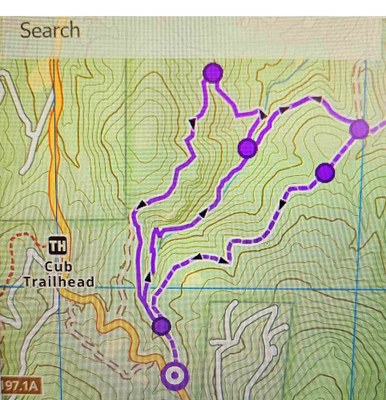
This hike from the Upper Trailhead includes the standard Maxwell Falls Loop hike (2.4 mi) - plus another loop that uses Admin 4wd Rd (aka Maxwell Bluffs Trail) - for a total of 5.5 miles / 800 ft elevation gain. Approximately 4.25 hours total time, 3.25 hours hiking time at a pace of 1.5 mph.
- Thu, Jan 23, 2025
- Rocky Mountain Over the Hill Gang
- Hiking
- Adults
- moderate
- Moderate
- Mileage: 5.5 mi
- Elevation Gain: 800 ft
- Pace: Casual Plus ( 1.6 mph)
- 4 (11 capacity)
- Cancellation & Refund Policy
Weather Report: Partly cloudy skies. High 23F. Winds WNW at 10 to 15 mph.
Trail Conditions: Mostly hard-packed snow with possible sections of water ice.
Spikes Required. Poles are recommended for balance and helping to prevent falls – especially when descending icy sections.
Please let me know if you have any medical issues / conditions you may have so that I will be prepared to help you in the event of an emergency.
Personal Info Card: https://cmcdenver.org/wp-content/uploads/Personal-Information-Form-7-6-16.pdf Please remember to bring your "Personal Information Card" to keep in your 1st Aid Kit or in an easily accessible pocket on your backpack. In the event of an emergency this information will be essential.
Please be packed up and ready to roll after some intros . There are no restrooms at the trailhead.
Please bring some sort of trash bag to either put muddy/snowy boots in or to place on the floor of the driver's vehicle to help keep their vehicle clean.
Carpool Driver Donation: Let's remember that we are reimbursing the drivers for the gas expense, wear & tear on their vehicles, and getting chauffered to our hike:) Please split $20 among the passengers in your carpool.
Feel free to contact me with any questions or concerns you may have. I look forward to fun outing with you all.
Tim Lane (303-503-1914) / timlane54@gmail.com
Meet at 9 am at RTD Twin Forks Park n Ride: 6164 US Highway 285, Morrison, CO.
From the "285 South" exit of 470 (Exit 5A) drive approximately 5 miles and look for turn-off on the left. From here we will carpool to the Upper Maxwell Falls Parking / Trailhead:
8399 Black Mountain Dr, Conifer, CO
Directions from RTD To Trailhead: Drive 7.9 miles towards Conifer and take right at the Barkley Rd exit (near the King Soopers Gas Station - Not the King Soopers Grocery Store). There are actually several exits on the right that will get you onto Barkley "Frontage" Rd. Barkley will dead end on CO 73. Take a right, go a short distance, and take a left on Shadow Mountain Dr (CR-78). Drive 5.1 miles to Trailhead Parking on your right. (Note that Shadow Mountain Dr becomes Black Mountain Dr).
Required Equipment
Microspikes Required.
Be prepared for any Winter conditions (despite the weather report).
This is a Moderately Challenging route so please assess your cardiovascular conditioning.
