Trip
Hiking – Pitkin Lake
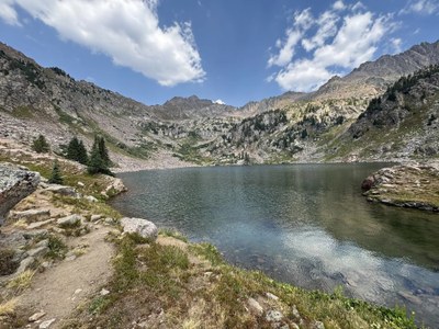
The hike to Pitkin Lake in the Eagles Nest Wilderness is one of the most scenic in the Vail area. The long and steep trail runs west of Pitkin Creek for 9.9 miles to reach lovely Pitkin Lake just below timberline in a rocky bowl.
Contacts

- Fri, Aug 7, 2026
- Pikes Peak
- Hiking
- Adults
- Challenging
- Mileage: 9.9 mi
- Elevation Gain: 2,900 ft
- High Point Elevation: 11,380 ft
- Pace: 2.0 mph
- FULL, 2 on waitlist (8 capacity)
- Cancellation & Refund Policy
Begin the hike north from the trailhead sign and quickly cross Pitkin Creek and ascend steeply. Within 1 mile the grade becomes more gradual. After 2.5 miles, Lower Pitkin Falls is visible on the right (east). Continue up through a series of rocky benches and lush meadows to finally reach Pitkin Lake at the head of the valley. The nearby peaks are part of the Gore Range. The imposing peak to the north-northwest is called West Partner. The equally formidable peak the northeast is called East Partner. The lake is named after Frederick Pitkin who was a Colorado governor between 1879 and 1883.
The Pitkin Lake Trail TH ready to hike at 7:15 am. Take exit 180 off I70 west of Vail Pass and before Vail. Turn right onto Big Horn Road. Turn right onto Fall Line Drive. Go about a third of a mile, cross Pitkin Creek and the TH will be on the left.
This is a popular TH with limited spaces. If you drive separately, you may want to consider arranging a carpool from the Vail Pass Rest Area.
Required Equipment
TK