Trip
RMOTHG Trip – South Mesa TH - South Boulder Peak re Shadow Mountain Trail
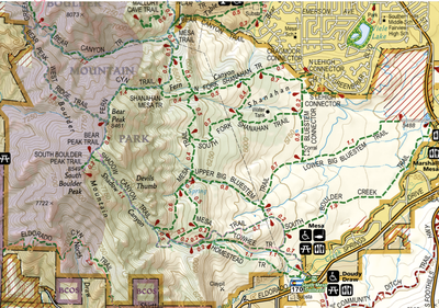
We will be hiking up South Boulder Peak from the South Mesa Trailhead via the Homestead and Shadow Mountain Trails.
- Wed, Jun 11, 2025
- Rocky Mountain Over the Hill Gang
- Hiking
- Adults
- Challenging
- Mileage: 8.8 mi
- Elevation Gain: 2,960 ft
- High Point Elevation: 8,549 ft
- Pace: 1.5 avg moving speed
- FULL (6 capacity)
- FULL (3 capacity)
- Cancellation & Refund Policy
This is a challenging out and back hike. It is challenging due to its elevation gain and the steepness and unevenness of parts of the trail. It also has several stretches where you will be climbing stairs like up large rocks.
Here’s a link to this hike in AllTrails: https://www.alltrails.com/trail/us/colorado/south-boulder-peak-trail
Meet at 6:50 for a 7:00 am departure from the Clear Creek Parking Lot. This is at 10th Street and Archer. There are porta pots at the parking lot. Here’s a Google Maps Link to the “Clear Creek Parking Lot”: https://maps.app.goo.gl/LwZAdnVTp64XqEqj9
We will be starting our hike from the South Mesa Trailhead. This is on Eldorado Springs Drive, 1.8 miles west of CO Hwy 93. Here’s a Google Maps Link to the “South Mesa Trailhead”: https://maps.app.goo.gl/bGY1yaZ8KX9zEumr8
Required Equipment
$15 annual RMOTHG Membership Dues are required to participate. Please contact the office at 303-279-3080 ext. 3 or office@cmc.org to join!
Hiking Sticks will be handy on the steeper sections. Be sure to bring your 10 essentials
