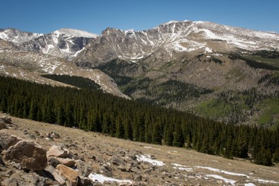
Gray Wolf Mountain
Hike up to tree line, then over tundra. Great views of Mt. Evans range.
For more information see: Gray Wolf Mountain : Climbing, Hiking & Mountaineering : SummitPost
Additional information at: Arapaho & Roosevelt National Forests Pawnee National Grassland - Recreation (usda.gov)
Gray Wolf Mountain is a 13er north of Mt. Evans. Gray Wolf is across a wide and gentle basin that forms the head of the north fork of Scott Gomer Creek.
Chicago Creek Trail - distant 8.8 miles - elevation gain 3654 ft
Summit Lake Trail - distant 11 miles - elevation gain 3,300 ft
- Suitable Activities: Hiking
- Seasons: May, June, July, August, September, October, November
- Weather: View weather forecast
- View avalanche forecast.
- 13,604 ft
-
Land Manager:
U.S. Forest Service
Mount Blue Sky Wilderness Area (formerly Mount Evans), Clear Creek Ranger District (ARNF)
- Parking Permit Required: USFS Permits & Passes
- Recommended Party Size: 12
- Maximum Party Size: 15
- Maximum Route/Place Capacity: 15
This is a list of titles that represent the variations of trips you can take at this route/place. This includes side trips, extensions and peak combinations. Not seeing a title that fits your trip? Log in and send us updates, images, or resources.
- Gray Wolf Mountain - via Chicago Creek Trail
- Gray Wolf Mountain - via Summit Lake Trail
There are no resources for this route/place. Log in and send us updates, images, or resources.
