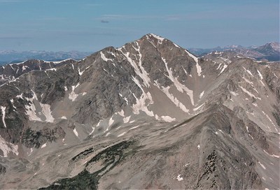
Huron Peak
Huron Peak (14,012') is a high mountain Collegiate Peak in the Sawatch Range, 18 miles west-northwest of Buena Vista
Huron Peak (14,012') has at least three standard approaches, all involving at least a bit of Class 2 scrambling.
Alternate titles:
The Standard Route is Huron Peak via Northwest Slopes from the S. Winfield/Lake Ann TH - 7 miles, 3500' gain - Class 2.
Huron Peak via Southwest Slopes, also from the S. Winfield/Lake Ann TH - 9 miles, 3600' gain - Class 2.
Huron Peak via LuLu Gulch, also from the S. Winfield/Lake Ann TH - 8.4 miles, 3980' gain - Class 2. A longer and more scenic way up Huron, 11mi/4,300ft gain. From Winfield up Lulu Gulch, over Middle Mountain, UN13462, Browns Peak. Return via standard route. Route is a mix of dirt road, class 2 ridge, and class 1 trail. Much less traveled than the standard route.
- Suitable Activities: Backpacking, Camping, Hiking, Scrambling, Ski Mountaineering, Snowshoeing
- Seasons: June, July, August, September
- Weather: View weather forecast
- Avalanche Terrain Rating Complex View avalanche forecast.
- Difficulty: Difficult
- 14,012 ft
-
Land Manager:
U.S. Forest Service
Collegiate Peaks Wilderness Area, Leadville Ranger District (PSINF)
- Parking Permit Required: USFS Permits & Passes
- Recommended Party Size: 12
- Maximum Party Size: 12
- Maximum Route/Place Capacity: 12
- 14'ers.com
- USFS
- SummitPost
This is a list of titles that represent the variations of trips you can take at this route/place. This includes side trips, extensions and peak combinations. Not seeing a title that fits your trip? Log in and send us updates, images, or resources.
- Huron Peak via NW slopes
- Huron Peak via SW slopes
- Huron Peak via LuLu Gulch
There are no resources for this route/place. Log in and send us updates, images, or resources.