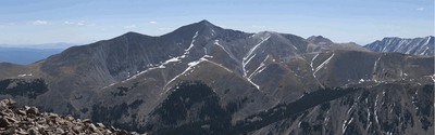
Mt. Antero
A 14,271' peak at the north end of the San Luis Valley. It affords fine views of the Valley and the San Juan, Sangre De Cristo, and Sawatch ranges.
A 14'er at the north end of the San Luis Valley. It affords fine views of the Valley and the San Juan, Sangre De Cristo, and Sawatch ranges.
For further information and any restrictions see: Mount Antero : Climbing, Hiking & Mountaineering : SummitPost and 14ers.com
See the link for complete details: https://www.14ers.com/peaks/10010/mount-antero
Alternative Titles:
According to 14ers.com, the standard approach is the West Slope - 15.2 miles and 4,842' gain - Class 2. Using the Baldwin Trailhead.
A secondary approach is from the Browns Creek Trailhead - 16.25 miles, 5550' gain - Class 2.
- Suitable Activities: Camping, Hiking
- Seasons: June, July, August, September, October
- Weather: View weather forecast
- View avalanche forecast.
- Difficulty: Mod C
- Elevation Gain: 4,842 ft
- 14,271 ft
-
Land Manager:
U.S. Forest Service
Saguache Ranger District (RGNF)
- Parking Permit Required: USFS Permits & Passes
- Recommended Party Size: 10
- Maximum Party Size: 15
- Maximum Route/Place Capacity: 15
- 14ers.com
- SummitPost
This is a list of titles that represent the variations of trips you can take at this route/place. This includes side trips, extensions and peak combinations. Not seeing a title that fits your trip? Log in and send us updates, images, or resources.
- Mt Antero - West Slope
- Mt Antero - Browns Creek
There are no resources for this route/place. Log in and send us updates, images, or resources.