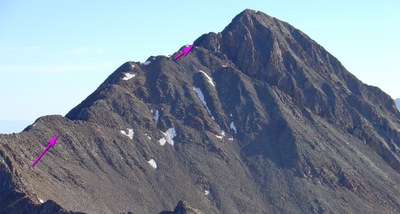
Wilson Peak
Wilson Peak is near Mount Wilson and Telluride. This 14'er is the peak in the Coors beer logo.
Wilson Peak (14,023') is located in the Lizard Head Wilderness of the Uncompahgre National Forest, in the southern San Juan Mountains. It is the highest point in San Miguel County. Its base is accessible by four wheel drive roads 11 miles west of Telluride, Colorado.
For more information, tracks, and routes go to 14ers.com.
Alternative Titles:
Navajo Lake Approach - 9.5 miles, 2000' gain - Class 1
Rock of Ages Approach - 8.5 miles, 2800' gain - Class 1
Kilpacker Approach - 6 miles, 800' gain - Class 1
Woods Lake Approach - 9 miles, 2115' gain - Class 1
Southwest Ridge - 10 miles, 3900' gain - Class 3
East Face - 12 miles, 4900' gain - Class 3 (snow route)
- Suitable Activities: Hiking, Mountaineering, Scrambling
- Seasons: June, July, August, September, October
- Weather: View weather forecast
- View avalanche forecast.
- 14,023 ft
-
Land Manager:
U.S. Forest Service
Lizard Head Wilderness Area, Norwood Ranger District (GMUG)
- Parking Permit Required: USFS Permits & Passes
- Recommended Party Size: 6
- Maximum Party Size: 6
- Maximum Route/Place Capacity: 6
- 14'ers.com
- climb13ers.com
- Summit Post
- Wikipedia
- COTREX
- allTrails
This is a list of titles that represent the variations of trips you can take at this route/place. This includes side trips, extensions and peak combinations. Not seeing a title that fits your trip? Log in and send us updates, images, or resources.
- Wilson Peak - Navajo Lake Approach
- Wilson Peak - Rock of Ages Approach
- Wilson Peak - Kilpacker Approach
- Wilson Peak - Woods Lake Approach
- Wilson Peak - Southwest Ridge
- Wilson Peak - East Face
There are no resources for this route/place. Log in and send us updates, images, or resources.