Colorado's Best Hikes for Fall Colors, the latest guidebook to be published by CMC Press, describes hikes to 45 of Colorado’s best places to see fall colors.
Order your copy of Colorado's Best Hikes for Fall Colors today!
*****
Ben Tyler Trail
Rating Difficult
Round-Trip Distance 12.5 miles
Elevation Gain 3,700 feet
Round-Trip Time 8 hours
Maps Trails Illustrated 105: Tarryall Mountains, Kenosha Pass
Main Attraction A difficult hike close to the Front Range with views of a huge aspen grove
COMMENT: One of the Front Range’s best hikes for fall color, the Ben Tyler Trail ascends steeply into a massive aspen grove before topping out at a high saddle with sweeping vistas.
GETTING THERE: The Ben Tyler Trail is located 6.8 miles west of Bailey on the south side of US Highway 285. The trailhead is marked by a small brown sign on the south side of the road and is often quite busy.
TRAILHEAD: The Ben Tyler Trailhead has parking for around fifteen vehicles and is very close to the highway. Use caution when leaving the trailhead as traffic on US 285 is moving fast! The trail starts at the east end of the parking shoulder.
THE ROUTE: The trail begins on the edge of the highway and immediately gains 300 feet over the course of twelve switchbacks and 0.4 mile. Above the switchbacks, leave the sounds of the road behind and continue to climb through ponderosa pines before leveling off and traversing more open terrain along a trail flanked by mountain mahogany bushes (look for their incredible curly seed tails in the fall and winter) and offering views of Ben Tyler Gulch above. At 1.3 miles, sign in to the wilderness area at the register box and enter a forested section of trail soon thereafter. At 1.6 miles, the trail nearly touches the creek and offers a junction to some camping options. Do not cross the creek and instead continue uphill.
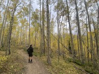
From here, the trail steepens on often rocky trails before finally crossing the creek at 2 miles. The trail begins to ascend even more rapidly here but soon puts you in a massive aspen grove that can feel like a hallway of yellow leaves from mid-September onward. As the trees periodically open up, you’ll catch glimpses of the other side of the hill covered in aspens.
At 10,580 feet and 4 miles from the trailhead, the first set of switchbacks begins. For the next half mile, you will be rewarded with sweeping views back down the gulch, filled with aspens. After this, the trail goes from a “moderate” endeavor to a “difficult” one, and the aspen show fades into the background in favor of an approach to the tundra. Turn back if you were only in it for the fall colors or continue if you want the alpine views.
The second of three sets of switchbacks begins at 4.8 miles, and the trail meets up with the Craig Park Trail at 5 miles. Stay to the right to continue climbing the Ben Tyler Trail. Traverse the final set of switchbacks at 5.5 miles, winding through bristlecone pines before emerging onto the alpine tundra at the 6-mile mark. The rolling saddle offers views of South Park and the Collegiate Peaks to the southwest and Mounts Evans and Bierstadt to the north. Return the way you came.
I rated this trail “difficult” because of the steep climbs in the middle of the hike. The terrain is often rocky and loose. Routefinding above tree line can get slightly complicated as multiple social trails crisscross the landscape and official trails branch off to other parts of the wilderness area. The round-trip hike is lengthy and requires you to assess the fitness and stamina of the group.
If you are looking to make a fantastic day hike into a backpacking trip, this is an ideal option that can combine multiple colorful hikes into a single adventure. Combine the Ben Tyler Trail up over the Kenosha Mountains. From the top of this hike, it is possible to descend Ben Tyler Gulch on the south side of the mountains until it meets the Colorado Trail. Continue west to the Kenosha Pass hike listed in Hike 5. Stationing one car at Kenosha Pass and another at the Ben Tyler Trailhead would make an easy point-to-point 17.8-mile hike that combines two fantastically colorful hikes close to the Front Range.
 Sarah Gorecki
