Trip
Hiking – Goose Creek Trailhead
Shaft House via Goose Creek LIT Hike
- Sun, Nov 3, 2024
- Pikes Peak
- Hiking
- Adults
- Moderate
- Mileage: 9.5 mi
- Elevation Gain: 1,100 ft
- High Point Elevation: 8,761 ft
- Pace: 2.3 mph
- 4 (6 capacity)
- FULL (2 capacity)
- Cancellation & Refund Policy
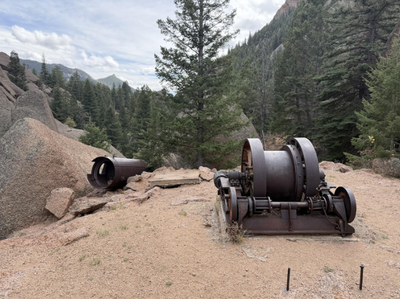
This is the LIT hike for Scott Baugher. We will be hiking to the Shaft House historical site on an out and back route in the Lost Creek Wilderness. Approximately 2 miles into the hike, we will take in views of Harmonica Arch across the valley while taking a short break. After approximately another 2.5 miles, we will arrive at the cabins used by the workers in their attempt to dam Lost Creek. We will take a short 0.25 mile side trip to see the remains of the shaft house, before returning to the cabins for an early lunch and brief talk about the history of the place. We’ll then return the way we came.
1-2 inches of snow is forecasted to fall in the area on the Wednesday prior. While I expect this snow will melt due to the low elevation and higher temperatures, please bring microspikes just in case. While this trail is not terribly steep, there are a couple of very short moderately steep and loose sections, so please bring hiking poles if you normally use them.
Round trip from carpool to location to trailhead is 112 miles. Based on $0.34/mile, per car cost will be $38, to be divided among occupants.
While the total time for the hike will be dependent on the skills and abilities of the hikers who sign up, I expect the hike will take no more than five hours total, including a couple of brief breaks and a stop for lunch at the cabins. The total driving time from the carpool location is approximately 1:45 each way.
Goose Creek Trail to Shaft House hike found here: https://www.alltrails.com/trail/us/colorado/shaft-house-via-goose-creek
For those wishing to carpool, we will meet at the Safeway parking lot in Old Colorado City at 6:15 am for a 6:30 am departure. A Google Maps link to the Safeway is here: https://maps.app.goo.gl/cJjNStnvNcUituS96
For those wishing to meet at the trailhead, please arrive by 8:15 am ready to hike. We will do brief introductions and get on the trail by 8:30 am sharp. A Google Maps link to the trailhead is here: https://maps.app.goo.gl/Vuic6yPYHiFyzvJP9 Please be aware that access to the trailhead is via an approximately 13 mile long maintained forest service dirt road. While a 4x4 is not required, there were a few rough/washboarded spots along the way when I drove it on October 17th.
Required Equipment
Ten essentials plus microspikes and hiking poles (as desired).
