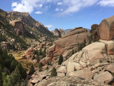
Goose Creek Trailhead
Goose Creek Trailhead is the gateway to the southeast corner of Lost Creek Wilderness. After a short (0.2 mile) walk down to a stream, Goose Creek Trail heads north and Hankins Pass Trail heads west. Many trips are possible from this location, some of which listed in the description below.
Shaft House:
A typical trip would be 10 miles, 1500 feet elevation, on easy trails. It would be an 8-mile round trip only to the historic cabins; add 0.5 mile RT to go down to where Goose Creek emerges from its final underground course and add 1.5 mile RT to go to the Shaft House. Getting to the overlook beyond the Shaft House requires some Class 3 scrambling which is 100% worth it! Many short side trails to vistas of rock formations and other extensions possible. Throughout the hike, there are great views of the rock formations that make Lost Creek so amazing, including Harmonica Arch. Just before the 4-mile point, watch for a sign pointing down a tributary to the left that says "historic buildings." These include two semi-intact cabins, some other ruins, and even an old car if you can find it. One option here is to continue beyond the cabins downhill to Goose Creek and then upstream a short distance to the upwelling. Another option is to take the side trail just before the cabins to the old machinery of the Shaft House and beyond to an amazing overlook of Lost Creek. Spectacular any time of year!
Hankins Gulch:
The trail criss-crosses a stream for several miles before emerging into open parks surrounded by aspen, some of which is regrowth after the 2002 Hayman Fire. One possible destination is a knoll on the south side of the largest meadow, which would be a 6-mile, 1200' round trip. Continuing to Hankins Pass and the junction with the Lake Park Trail would make it an 8.5 mile, 1800' round trip. Excellent variety of wildflowers in early summer and spectacular leaves in the fall.
- Suitable Activities: Hiking
- Snowshoeing Category: Basic
- Seasons: Year-round
- Weather: View weather forecast
- Length: 10.0 mi
- Elevation Gain: 1,500 ft
- 8,800 ft
-
Land Manager:
U.S. Forest Service
Lost Creek Wilderness Area, South Platte Ranger District (PSINF)
- Parking Permit Required: USFS Permits & Passes
- Recommended Party Size: 12
- Maximum Party Size: 12
- Maximum Route/Place Capacity: 12
This is a list of titles that represent the variations of trips you can take at this route/place. This includes side trips, extensions and peak combinations. Not seeing a title that fits your trip? Log in and send us updates, images, or resources.
- Goose Creek TH - Shaft House
- Goose Creek TH - Hankins Gulch
There are no resources for this route/place. Log in and send us updates, images, or resources.
