Trip
Hiking – Lost Park TH - Lost Creek to the McCurdy Park Trail
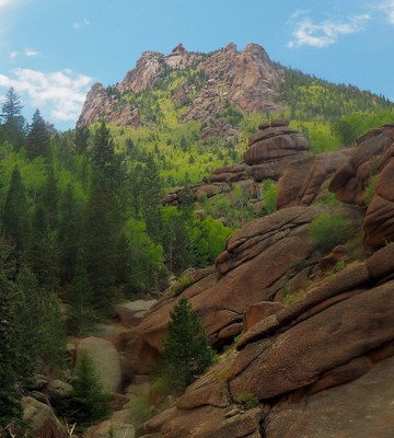
A challenging, mostly off-trail hike along upper Lost Creek, passing cascades, interesting rock formations, and two places where Lost Creek goes under boulder fields.
- Thu, Jun 12, 2025
- Bobcats Section
- Hiking
- Adults
- Challenging
- Challenging
- Mileage: 13.0 mi
- Elevation Gain: 2,050 ft
- High Point Elevation: 10,000 ft
- Pace: 1.5 to 2.5 depending on terrain
- 2 (6 capacity)
- Cancellation & Refund Policy
This out-and-back hike explores the upper section of Lost Creek. Starting in Lost Park (10,000 ft., near Lost Park Campground) we'll hike on the Wigwam Trail then diverge to a social trail/route that parallels Lost Creek. This route runs adjacent to Lost Creek as it descends a quarter-mile cascade and then crosses the submerged creek twice. The first crossing is where the creek flows beneath a boulder field, the second a bit farther where the route crosses a valley of house-sized boulders with the watercourse below. Our turnaround goal will be a viewpoint that looks down on the Lost Creek valley and its rock formations. This route entails some class 2 scrambling and bushwhacking.
Meet at the Morrison Park and Ride (“PnR”) at 6:15am, so we can form carpools and leave no later than 6:30am. The “Morrison PnR” is at the northwest corner of the Morrison Road exit off C-470. Here’s a Google Maps link to the “Morrison PnR”: https://maps.app.goo.gl/mpG84vtWp2eCEGxU8
We'll start at the Lost Park trailhead, adjacent to Lost Park Campground. This is on County Road 56, 21 miles southeast of Jefferson off of US 285. Here’s a Google Maps link to the “Lost Park Campground”: https://maps.app.goo.gl/vcVFdJK9Kouh2uB9A
Required Equipment
Ten essentials and a desire to have a great time hiking!
