Trip
Hiking – Meadow Creek TH - Buffalo Mtn Loop
This is a Difficult 14-mile hike due to the elevation gain and pace, with 3,500 vertical feet of gain over Eccles Pass. Includes alpine views and a waterfall.
- Sat, Jun 28, 2025
- Bobcats Section
- Hiking
- Adults
- Difficult
- Difficult
- Mileage: 14.0 mi
- Elevation Gain: 3,500 ft
- High Point Elevation: 11,900 ft
- Pace: 2.75 mph on level trail (sustainable, not burst) and >1,000 ft/hr
- 2 (6 capacity)
- FULL (1 capacity)
- Cancellation & Refund Policy
Please make sure you're comfortable with the pace and elevation gain
Our trip has a Difficult rating due to elevation gain and pace. If you have not already been doing hikes of at least 3,000' vertical gain this season then this trip is not for you (please email me for an exception). Expect this trip to take 7-8 hours from the trailhead.
This trip was originally posted for Thursday June 19 but rescheduled due to reconstruction of the Meadow Creek Trail.
Route
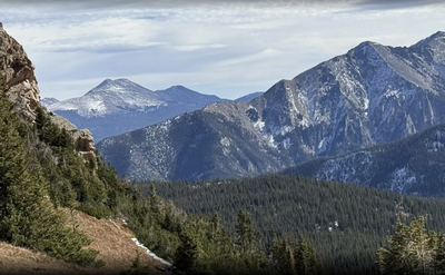
This 13.7 mile loop travels on-trail through forest and above timberline. The total elevation gain is almost 3,500’ for the day. We’ll park at the Meadow Creek TH at 9,140’ and follow the Meadow Creek Trail north to Eccles Pass (11,915’) before continuing down the Gore Range Trail, across the Buffalo Cabin Trail, and back to the start on the Lily Pad Lake Trail. We’ll be above timberline for a bit, so please bring appropriate layers (including sun protection and a rain jacket) for hiking at altitude. There is easy water access below timberline if you choose to treat your water; alternatively, please plan on 3 liters if you will be carrying from the trailhead.
This hike is anticipated to take roughly 7-8 hours to complete, although our actual time may be different based on weather, strength of the group, length and frequency of stops, and other factors.
If you’d like to know more about the route, please check out the links below. This route travels through the Eagles Nest Wilderness within the Dillon Ranger District in Arapaho National Forest.
More information:
Weather: Link to weather.gov for Eccles Pass
Map: Link to CalTopo for route
Trail info: Hiking Project
Trail info: All Trails
I will send more information a few days before our trip, including a .gpx track and weather report. Please email to let me know if you have any immediate questions or if you'd like more information.
We will carpool from the Wooly Mammoth PnR, Section BB at 6:00 for a 6:15 departure. Here's a link to Google Maps.
Our trip will start from the Meadow Creek trailhead in Frisco. Here's a link to Google Maps. Our goal is to start hiking by 7:30AM.
CMC suggests that all occupants of a vehicle share the costs of driving. Based on a reimbursement rate of $0.34 per mile, the total amount for the 114-mile roundtrip drive via I-70 is about $39 per vehicle. This cost typically is divided by the total number of people in the vehicle, including the driver.
Meadow Creek Trailhead
-
AllTrails
CoTrex
PeakBagger
SummitPost
onX Backcountry - See full route/place details.
Required Equipment
10 Essentials
