Trip
Hiking – Orbital Trail - Segment 15
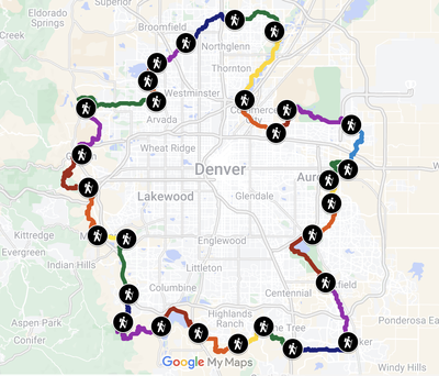
For Rocky Mountain Over the Hill Gang members ONLY. We will hike segments 15 AND 14 of the Denver Orbital Trail (DOT), starting at the Highline Canal and ending on the other side of Parker Rd. from Cherry Creek State Park. We will be hiking from north to south. Please note the pace before you sign up.
- Wed, Mar 5, 2025
- Rocky Mountain Over the Hill Gang
- Hiking
- Adults
- Easy to Moderate, Easy to Moderate
- Moderate
- Mileage: 7.8 mi
- Elevation Gain: 350 ft
- High Point Elevation: 5,700 ft
- Pace: 2.4
- FULL (8 capacity)
- FULL (2 capacity)
- Cancellation & Refund Policy
The first part of the hike will be on the Highline Canal. At Alameda we switch to the Toll Gate Trail and eventually join the Cherry Creek Spillway Trail, until we get back to the Parker East Trail and take it north to get back to our cars. Drivers with cars there will shuttle the others back to their cars at the Save-a-Lot Parking Lot.
I do not know exactly about toilets on the route but we will be passing through or by Horseshoe Park, Toll Gate Park (closed in winter), Wheel Park, and Olympic Park.
This route is exploratory for the trip leaders. We will write a day or before trip day to review the weather and any logistical adjustments.
Dress appropriately for the weather, including sunscreen and a hat, wind clothes. Bring a lunch and plenty of water. Assume a cold start. Microspikes may be required.
If you are interested in carpooling from somewhere further west, so indicate in a Registration Note and I will let the others know about that interest, but it will be up to you to arrange any carpool and the sharing costs.
See the two maps and download the two gpx tracks at AllTrails linked from the route place information down above the map but note that our group will be following the routes shown at AllTrails IN REVERSE.
We meet BY 9:00 am AND DROP SHUTTLE CARS at a parking area across Parker Rd from Cherry Creek State Park, south of the office building at 3300 S Parker Rd Aurora, CO 80014. https://maps.app.goo.gl/vpUPtwtgnssdBvxG8. We then will carpool to the SW corner of E. 6th Ave and Chambers, parking in the furthest northeast corner of the Save-a-Lot parking lot along Chambers Rd. https://maps.app.goo.gl/R43qpxyfm3tbE5SYA.
Since the distance between trailheads for the shuttle is short and many of us will be driving one direction or the other, there will be no carpool cost sharing for the shuttle.
Suzanne Dysard WILL NOT be leading another hike from south to north on the same day, but she plans to make it up later on a day of the week other than Wednesday so we can get back in sync.
Exact Driving Directions to the drop cars/hike end point: Take Exit 4 on I-225. Go south on Parker Rd. Enter Vaughn Way. from Parker Rd. and follow it to the 4-way stop sign, turning right onto S Heather Gardens Way. Turn right at the first intersection onto Wheeling St. Turn right towards the building at 3300 S Parker Rd and immediately turn left and park in the parking area furthest from the building or in the cul-de-sac, against the curb.
Required Equipment
Dress appropriately for the weather, including sunscreen and a hat, wind clothes. Bring a lunch and plenty of water. Expect a cold start. Microspikes may be required.
