Trip
RMOTHG Trip – Rolling Creek Trailhead
This is an out and back, on-trail, RMOTHG hike along Rolling Creek from Co. Rd. 68 eight miles south of Bailey to the boundary of the Lost Creek Wilderness Area.
- Mon, Jun 2, 2025
- Rocky Mountain Over the Hill Gang
- Hiking
- Adults
- Easy to Moderate
- Easy
- Mileage: 5.5 mi
- Elevation Gain: 700 ft
- High Point Elevation: 8,360 ft
- Pace: 1.4 - 1.7 mph
- FULL, 7 on waitlist (7 capacity)
- FULL (1 capacity)
- Cancellation & Refund Policy
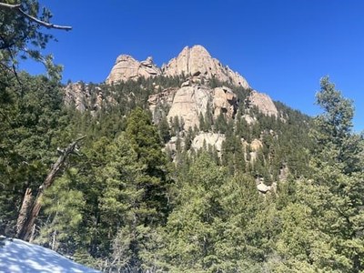
The Rolling Creek Trail has lots of ups and downs as it winds its way through shaded forests and open meadows with the gurgling sound of water flowing through the creek. It offers panoramic views of the surrounding mountains and valleys with great views of The Castle near Wellington Lake. There are nice scenic spots along the way. We’ll hike from the trailhead to the boundary of the Lost Creek Wilderness or a little further if the group is interested, the weather cooperates and our legs and lungs allow. As a minimum, expect hiking 5.5 miles with 700 feet of elevation gain. It’s all on trail and is an out and back hike. A weather report will be furnished by email a few days before the hike.
The trail can be found on CalTopo at: https://caltopo.com/m/FSJE2SH
A map of the trail can be printed at this link: https://caltopo.com/p/LU52E
We will meet at the Fort Restaurant south of Morrison on Co. Rd 8 at 7:15 AM on Monday June 2nd for a no-later-than 7:30 departure. Be sure to park south of the entrance to the restaurant.
The driving distance to the trailhead is 43 miles one way -- 96 miles total driving distance @ $0.30 per mile = $28.80 per carload to be divided equally among all participants in the car, including the driver.
Required Equipment
10-essentials, sturdy boots, layers, food and water, rain jacket.
This is the standard language RMOTHG Leaders inserts here:
$15 annual RMOTHG Membership Dues are required to participate. Please contact the office at 303-279-3080 ext. 3 or office@cmc.org to join!
