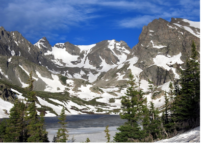
Apache Peak
Accessed from the Brainard Lake area, Apache Peak is a popular year-round destination for climbers and peakbaggers.
Apache Peak is ESE and above Lake Isabelle. At 13441’ elevation, this local highest point offers a scenic view of Lone Eagle Peak, its neighbor to the NE. Can traverse between Apache and Navajo Peaks. Apache is south of popular Pawnee and Buchanan passes. The peak may be accessed in summer by the class 2/3 East Ledges Route. Additional access includes the Queens Way couloir, which may be used as its own mountaineering destination or to ski Queens Way or Apache couloirs. Additional advanced routes include: the NW face (5.7, mixed ice/snow/rock); the Mohling Traverse; the Kasparov Traverse; and the Chessmen. Peak baggers may be interested to also summit neighboring Navajo Peak (13401’ elevation). Visitors should keep an eye for the downed C-47 aircraft, that crashed 12200’ near Niwot Ridge on January 21, 1948.
- Suitable Activities: Backcountry Skiing/Splitboarding, Climbing, Hiking, Mountaineering, Photography, Ski Mountaineering
- Climbing Category: Intermediate Alpine Climb
- Seasons: Year-round
- Weather: View weather forecast
- Length: 12.4 mi
- Elevation Gain: 3,100 ft
- 13,441 ft
-
Land Manager:
U.S. Forest Service
Indian Peaks Wilderness Area, Boulder Ranger District (ARNF)
- Parking Permit Required: Other
- Recommended Party Size: 12
- Maximum Party Size: 12
- Maximum Route/Place Capacity: 12
This is a list of titles that represent the variations of trips you can take at this route/place. This includes side trips, extensions and peak combinations. Not seeing a title that fits your trip? Log in and send us updates, images, or resources.
- Apache Peak
There are no resources for this route/place. Log in and send us updates, images, or resources.
