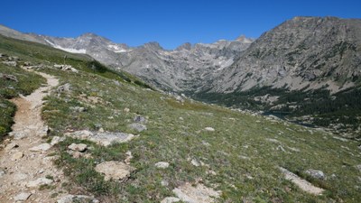
Arapaho Glacier Trail
Arapaho Glacier Trail #905 is 7.8 miles with an elevation range of 9,970-12,730ft. It is mostly above treeline, with picturesque views of Indian Peaks, City of Boulder Watershed Lakes, and Arapaho Glacier. The wildflowers from the west access are prolific and gorgeous in July!
Please view this document with everything you need to know about Indian Peaks Wilderness
There are two access points for this trail.
FROM THE EAST: Rainbow Lakes TH (before Rainbow Lakes Campground). The hike starts on the Arapahoe Glacier Connector Trail (0.3 miles in length). After 2.25 miles, the trail arrives at treeline and has gorgeous views of some of the Indian Peaks, the Boulder Watershed Lakes and to the east foothills/plains. The views improve the higher it climbs. The Arapaho Glacier Overlook is 6 miles from the TH. This is a 12 mile out-and-back hike with a total elevation gain of 3,130', elevation range: 9,970-12,730ft.
FROM THE WEST: Fourth/4th of July TH. Hike on the Arapaho Pass Trail #904. Treeline is at 1 mile. The trail intersection with Arapaho Glacier Trail #905 is at 2 miles near the remnants of the 4th of July Mine. This section of the trail is covered with abundant, gorgeous wildflowers in July and has great views up valley of Mt. Jasper and Mt. Neva. The Arapaho Glacier Overlook is 3.7 miles from the TH. This is a 7.4 miles out-and-back hike with a total elevation gain of 2,600', elevation range: 10,125-12,700'
- Suitable Activities: Hiking
- Seasons: July, August, September, October
- Weather: View weather forecast
- Length: 7.8 mi
- 12,730 ft
-
Land Manager:
U.S. Forest Service
Indian Peaks Wilderness Area, Boulder Ranger District (ARNF)
- Parking Permit Required: USFS Permits & Passes
- Recommended Party Size: 12
- Maximum Party Size: 12
- Maximum Route/Place Capacity: 12
This is a list of titles that represent the variations of trips you can take at this route/place. This includes side trips, extensions and peak combinations. Not seeing a title that fits your trip? Log in and send us updates, images, or resources.
- Arapaho Glacier Trail - Rainbow Lakes TH
- Arapaho Glacier Trail - 4th of July TH
There are no resources for this route/place. Log in and send us updates, images, or resources.
