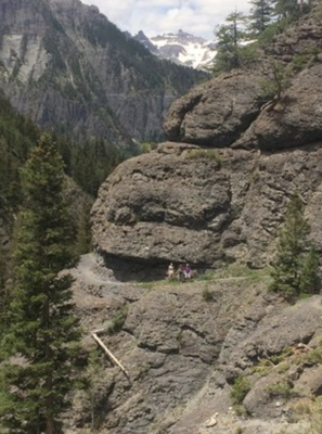
Bear Creek National Recreation Trail
This trail near Ouray is recognized as a National Recreation Trail because of its particularly unique, historic, and spectacular nature.
The "Trail" is made up of three connected USFS trails, #241, #241.1a, and #242. The trail starts along Hwy 550 with a series of long, moderately steep switchbacks ascending the east side of the Uncompahgre Gorge, a deep mountain canyon formed by the Uncompahgre River. The USFS information page has excellent maps and terrain profiles, as well as geological, biological, and historical information.
Trail parking is across U.S. 550 from the trailhead. Consistent grades, high elevation, cliffs, exposure, and rock types make the trail above average in difficulty.
- Suitable Activities: Hiking
- Seasons: Year-round
- Weather: View weather forecast
- Difficulty: Challenging
- Length: 8.0 mi
- Elevation Gain: 2,648 ft
- 11,119 ft
-
Land Manager:
U.S. Forest Service
Ouray Ranger District (GMUG)
- Parking Permit Required: USFS Permits & Passes
- Recommended Party Size: 12
- Maximum Party Size: 12
- Maximum Route/Place Capacity: 12
- COTREX
- Hiking & Walking
This is a list of titles that represent the variations of trips you can take at this route/place. This includes side trips, extensions and peak combinations. Not seeing a title that fits your trip? Log in and send us updates, images, or resources.
- USFS #241 and #241.1A RT -- 12 miles, 3910' gain
- USFS #241 and #242 RT -- 12.2 miles, 4360' gain
There are no resources for this route/place. Log in and send us updates, images, or resources.
