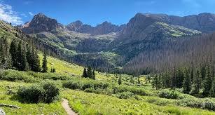
BPX 4-Day: Chicago Basin from Needleton Flagstop
This four-day adventure into the remote Chicago Basin combines rugged wilderness travel, alpine exploration, and the unique experience of riding the historic Durango & Silverton Narrow Gauge Railroad deep into the San Juan Mountains. Based from a backcountry camp in the basin, participants can choose between challenging ascents of several iconic 14ers or more moderate exploratory hikes to secluded alpine lakes, tarns, and high mountain passes surrounded by dramatic scenery. The trip blends strenuous mountaineering opportunities with flexible hiking options, all set within one of Colorado’s most spectacular and isolated alpine landscapes.
Suggested Backpacking Section (BPX) itinerary for 4-day trip to be used for CMC trips led by BPX leaders for BPX members.
Exploration of the Chicago Basin, with the option of either summitting some remote and difficult 14ers or exploring the area. Also includes a steam engine ride to and from the wilderness trailhead on the Durango & Silverton Narrow Gauge Train.
Day 1: Take the Durango & Silverton Narrow Gauge Train from Durango to the Wilderness Access at Needleton Flagstop. From Needleton Flagstop, hike along the Needle Creek Trail (#504) to the campsite location in the Chicago Basin (6.0 miles, +2,915 / -92 ft.)
Day 2: Do an optional day hike to summit two 14ers, or hike to Columbine Lake or hike to Hazel Lake.
Optional Day Hike: Sunlight Peak and/or Windom Peak: (1) Sunlight Peak (Sunlight Peak - South Face Route Description | 14ers.com) (Class 3 with precipitous Class 4 to get to the very top), (2) Windom Peak (Windom Peak - West Ridge Route Description | 14ers.com ) (difficult Class 2) (6.54 mile, +-4,027 ft.)
14ers Route: Chicago Basin BPX - CalTopo
Optional Day Hike: Columbine Lake (6.1 miles, +-2,229 ft.)
Optional Day Hike: Columbine Lake + Hazel Lake (6.8 miles, +-2,304 ft.)
Day 3: Do an optional day hike to summit two 14ers, or hike to either an Alpine Tarn in the cirque of the 14ers, or hike to Trimble Pass.
Optional Day Hike: 14ers: (1) Mount Eolus (Mount Eolus - Northeast Ridge Route Description | 14ers.com) (Class 3), (2) North Eolus (North Eolus - South Ridge Route Description | 14ers.com) (Class 3) (6.1 miles, +3184 / -3184 ft.)
14ers Route: Chicago Basin BPX - CalTopo
Optional Day Hike: Alpine Tarn (3.4 miles, +-1,549 ft.)
Optional Day Hike: Trimble Pass (8.5 miles, +2,583 ft.)
Day 4: Return to Needleton Flagstop following the inbound route (6.0 miles, +92 / -2,915 ft.). Optional morning hike to explore the Chicago Basin area.
Overall Route: 12.0 miles, +-3,013 ft.
NOTE(S):
- Always practice Leave No Trace techniques.
- Please view this document (Chicago Basin Backpacking, SW Colorado, Needleton Train, Needle Creek) for information about Chicago Basin.
- More information about Weminuche Wilderness is available here.
- Chicago Basin BPX - CalTopo
- CMC Route & Place for Chicago Basin 14ers: Chicago Basin 14ers (Sunlight, Eolus, North Eolus and Windom) — The Colorado Mountain Club
- Reservation are required for the Durango & Silverton Narrow Gauge Train (All Aboard! - Official Durango & Silverton Narrow Gauge Railroad Train).
- Google Map Driving Directions: From the Colorado Mountain Club (Golden, CO) to the Durango train station. Because of the long drive, typically one would stay in Durango the night before.
- Suitable Activities: Backpacking
- Seasons: June, July, August, September
- Weather: View weather forecast
- Length: 12.0 mi
- Elevation Gain: 3,013 ft
- 11,006 ft
-
Land Manager:
U.S. Forest Service
Weminuche Wilderness Area, Columbine Ranger District (SJNF)
- Parking Permit Required: USFS Permits & Passes
- Recommended Party Size: 6
- Maximum Party Size: 8
- Maximum Route/Place Capacity: 12
- Trails Illustrated 140
- Outdoor Trail Maps Weminuche Wilderness Map Pack: East Map and West Map
There are no resources for this route/place. Log in and send us updates, images, or resources.