BPX 2-Day: Cherry Lake from Wild Cherry TH
This difficult 11.2 mile out-and-back takes you to Cherry Lake high in the Sangre di Cristo Wilderness just north of Crestone, with an option to make camp below or above tree line. You can add a day to the trip and summit a number of nearby 13'ers.
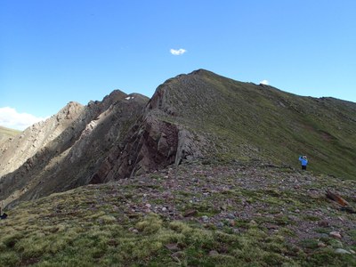
This hike in the remote western Sangre di Cristo Wilderness ascends almost 3,300 ft. to an alpine lake at 11,814 ft. The elevation gain with a full pack makes this a difficult backpacking trip. For those looking for a 3 day option with some peak-bagging, there are three 13'ers that can be approached from this trail -- Mt. Owen and Peaks 13,122 ft (AKA Wild Cherry Peak) and 13,490 ft. (AKA Cotton King Peak).
Suggested Backpacking Section (BPX) itinerary for 2-day trip to be used for CMC trips led by BPX leaders for BPX members:
Day 1: Starting at the Wild Cherry Trailhead (#748), hike 5.6 miles and find a campsite below Cherry Lake. There is a large meadow below the lake that will fit many tents, with water available a 5 minute walk up the trail and then cut to the right to small pond. (5.6 miles, +3,320 / -79 ft).
Day 2: Break camp and hike back to trailhead (5.6 miles, +79/ -3,320 ft.)
Alternate: 3-Day option. Get an early start and hike Peak 13,122 (also called Wild Cherry Peak) and on to Peak 13,490 (Cotton King Peak) and return to camp (this is a long ridge run with no water access; approximately 6 miles and 2500 vertical). Be advised, past trip leader reports this ridge hike took 6 hours to complete, so carry plenty of water. For another alternative, you can summit Mt Owen after leaving camp or before getting to camp.
Driving Directions: Take US 285 south to Villa Grove, then continue on 285 to CO-17. Take 17 to County Rd AA and turn left. Follow County Road AA for 8.2 miles to trailhead. Last section of road can be rough.
Possible ridge hike with two 13ers: There are no marked trails to the 13ers surrounding Cherry Lake, but there are resources online you can research for options to Peak 13,122 and 13,490. Trip leader will provide full itinerary for trips including the 13er climb.
- Suitable Activities: Backpacking
- Seasons: July, August, September
- Weather: View weather forecast
- Difficulty: Difficult
- Length: 11.0 mi
- Elevation Gain: 3,290 ft
- 11,814 ft
-
Land Manager:
U.S. Forest Service
Sangre de Cristo Wilderness Area, Saguache Ranger District (RGNF)
- Parking Permit Required: USFS Permits & Passes
- Recommended Party Size: 8
- Maximum Party Size: 12
- Maximum Route/Place Capacity: 12
- Trails Illustrated 138
This is a list of titles that represent the variations of trips you can take at this route/place. This includes side trips, extensions and peak combinations. Not seeing a title that fits your trip? Log in and send us updates, images, or resources.
- BPX 3-Day: Cherry Lake with 13ers from Wild Cherry TH
There are no resources for this route/place. Log in and send us updates, images, or resources.
