Brookside-McCurdy Trail
The Brookside-McCurdy Trail runs north-south through the Lost Creek Wilderness. The northern TH is Payne Creek/Brookside. The southern TH is Twin Eagles.
Brookside-McCurdy Trail - Twin Eagles TH:
To Lizard Rock: From Twin Eagles TH ascend the Brookside McCurdy Trail to Lizard Rock or to Hankins Pass. To Lizard Rock is an elevation gain on 1,082 ft and 3.2 miles one way. To Hankins Pass is 4.5 miles one way and elevation gain of 1,565 ft.
Brookside-McCurdy Trail - Payne Creek/Brookside TH:
This trailhead is on the north east end of the 32-mile major north-south thoroughfare through the middle portion of the Lost Creek Wilderness. There are junctions with Payne Creek Trail, Colorado Trail Segment #4, Wigwam, Craig Park, Ute Trail, Hankins Pass, and others.
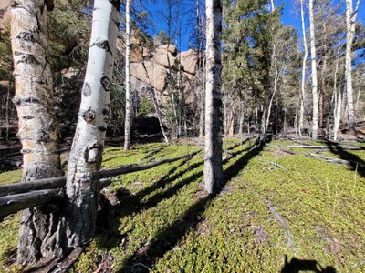
This TH is right in Bailey. It starts in a mixed pine forest and open meadow. The Payne Creek junction is about 1.75 miles in and then after the trail heads into the Lost Creek Wilderness. As it continues on it crosses through the Bison Peak area and ends at its Southwest terminus, at Twin Eagles TH on Park County Road 77.
- Suitable Activities: Hiking, Snowshoeing
- Seasons: Year-round
- Weather: View weather forecast
- View avalanche forecast.
- 10,000 ft
-
Land Manager:
U.S. Forest Service
Lost Creek Wilderness Area, South Platte Ranger District (PSINF)
- Parking Permit Required: USFS Permits & Passes
- Recommended Party Size: 12
- Maximum Party Size: 15
- Maximum Route/Place Capacity: 15
- All Trails
This is a list of titles that represent the variations of trips you can take at this route/place. This includes side trips, extensions and peak combinations. Not seeing a title that fits your trip? Log in and send us updates, images, or resources.
- Brookside-McCurdy Trail - Twin Eagles TH
- Brookside-McCurdy Trail - Payne Creek/Brookside TH
- Brookside-McCurdy Trail to Lizard Rock via Twin Eagles TH
There are no resources for this route/place. Log in and send us updates, images, or resources.
