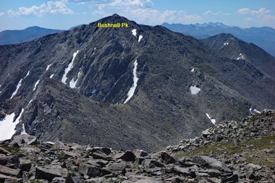
Bushnell Peak
A little known 13'er and Fremont County high point in the seldom-visited northern Sangre de Cristo Range.
Bushnell Peak is located on the boundary between Fremont and Saguache counties and on the divide between two national forests: the San Isabel National Forest to the east and the Rio Grande National Forest to the west.
The standard approach from the west is accessible from a 4wd road off of US-285.
Alternate Title:
Brook Creek Trailhead - 5.5 miles, 4000' gain
- Suitable Activities: Backpacking, Camping, Hiking
- Seasons: Year-round
- Weather: View weather forecast
- View avalanche forecast.
- Difficulty: Difficult
- Length: 5.5 mi
- Elevation Gain: 4,000 ft
- 13,112 ft
-
Land Manager:
U.S. Forest Service
Sangre de Cristo Wilderness Area, Salida Ranger District (PSINF)
- Parking Permit Required: Other
- Recommended Party Size: 12
- Maximum Party Size: 12
- Maximum Route/Place Capacity: 12
- climb13ers.com
This is a list of titles that represent the variations of trips you can take at this route/place. This includes side trips, extensions and peak combinations. Not seeing a title that fits your trip? Log in and send us updates, images, or resources.
- Bushnell Peak - Brook Creek TH
There are no resources for this route/place. Log in and send us updates, images, or resources.
