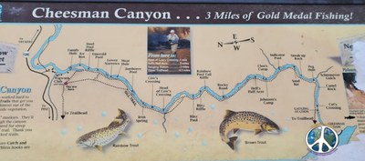
Cheesman Canyon
Cheesman Canyon Trail follows along the South Platte River to the Cheesman Reservoir. It is a popular fishing spot, known also for wildlife and flowers.
The Cheesman Canyon Trailhead is located along Jefferson County Route 126, approximately 22 miles from south of Pine Junction from US Highway 285.
The five-mile Gill Trail #610 follows the South Platte River through Cheesman Canyon and ends at the Upper Cheesman Reservoir trailhead. The trail is difficult and steep in many sections and there are no facilities in the canyon.
Help protect the canyon by staying on designated trails.
- Suitable Activities: Fly Fishing, Hiking
- Seasons: Year-round
- Weather: View weather forecast
- Length: 5.5 mi
- Elevation Gain: 510 ft
- 7,256 ft
-
Land Manager:
U.S. Forest Service
South Platte Ranger District (PSINF)
- Parking Permit Required: USFS Permits & Passes
- Recommended Party Size: 6
- Maximum Party Size: 6
- Maximum Route/Place Capacity: 6
- COTREX
- AllTrails
There are no resources for this route/place. Log in and send us updates, images, or resources.
