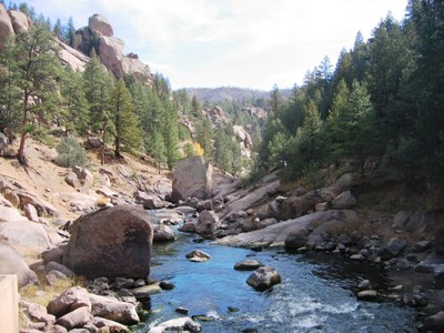
Corral Creek to South Platte River
This is an obscure gem of a trail that accesses the South Platte River in a remote valley above Cheeseman Reservoir (not to be confused with the better-known Corral Creek Trail near Frisco). Situated in the Pike National Forest and populated by huge rock formations, the closest towns are Lake George and Deckers.
Hike, backpack or mountain bike 1500 feet down an old 4wd road (now closed off) – through remnants of the 2002 Hayman Fire - to enjoy numerous beautiful spots for picnicking, camping, fishing or just splashing around in the South Platte River. The trail continues along the river for another 1.5 miles to where the Tarryall flows into the South Platte.
- Suitable Activities: Backpacking, Biking, Fly Fishing, Hiking
- Seasons: Year-round
- Weather: View weather forecast
- Difficulty: Moderate
- Length: 6.0 mi
- Elevation Gain: 1,500 ft
- 8,489 ft
-
Land Manager:
U.S. Forest Service
South Platte Ranger District (PSINF)
- Parking Permit Required: USFS Permits & Passes
- Recommended Party Size: 12
- Maximum Party Size: 12
- Maximum Route/Place Capacity: 12
- https://www.gaiagps.com/map/?loc=13.2/-105.3588/39.1328
This is a list of titles that represent the variations of trips you can take at this route/place. This includes side trips, extensions and peak combinations. Not seeing a title that fits your trip? Log in and send us updates, images, or resources.
- Forest Service Road 540
There are no resources for this route/place. Log in and send us updates, images, or resources.
