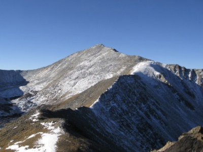
Cottonwood Peak A
A 13er in the Sangre de Cristo Range. It is a “Bicentennial Peak” i.e. one of Colorado’s highest 200 peaks.
Seldom-climbed Cottonwood Peak (13,597') straddles the Custer/Saguache Counties boundary. Hikers can access it via the Garner Creek Trail (USFS 752) or the Hot Springs Canyon Trail (USFS #753). In either case, some of the climb is off-trail. The two trails follow different canyons but leave from the same trailhead (8560'). Each requires turning and following a ridge up to the peak.
A loop can be made by following one trail up and the other trail down. Trails sometimes disappear for a bit. An excellent detailed stage-by-stage description of both trails/the entire loop can be found here.
Climbers often access this peak along with all the surrounding peaks from the east side of the range, but access is difficult.
Alternate Titles:
Garner Creek Trail - At a point located at 12703' elevation (38.124204, -105.443210) turn NW and follow the ridge about a mile to the summit, crossing by or over Peak 13123. Return the way you came. 11 miles, 5074' gain
Hot Springs Canyon Trail - At the saddle located at about 12300' elevation (38.125151, -105. 462905) and about 4.4 miles from the TH, turn east and head up the ridge about another mile+ to the summit. Return the way you came. 10 miles, 5259 gain.
Cottonwood Peak Loop - Hot Springs Canyon Trail up and Garner Creek Trail down (or in the reverse). 12 miles, 5500' gain.
- Suitable Activities: Climbing, Hiking, Scrambling
- Seasons: May, June, July, August, September, October, November
- Weather: View weather forecast
- Avalanche Terrain Rating Complex
- Length: 11.5 mi
- Elevation Gain: 5,500 ft
- 13,588 ft
-
Land Manager:
U.S. Forest Service
Sangre de Cristo Wilderness Area, Blanco Ranger District (WRNF)
- Parking Permit Required: USFS Permits & Passes
- Recommended Party Size: 8
- Maximum Party Size: 12
- Maximum Route/Place Capacity: 12
- AllTrails
- SummitPost
- 14'ers.com
- Peakbaggers
This is a list of titles that represent the variations of trips you can take at this route/place. This includes side trips, extensions and peak combinations. Not seeing a title that fits your trip? Log in and send us updates, images, or resources.
- Cottonwood Pk - Garner Creek TH
- Cottonwood Pk - Hot Springs Cyn TH
- Cottonwood Pk - Loop
There are no resources for this route/place. Log in and send us updates, images, or resources.
