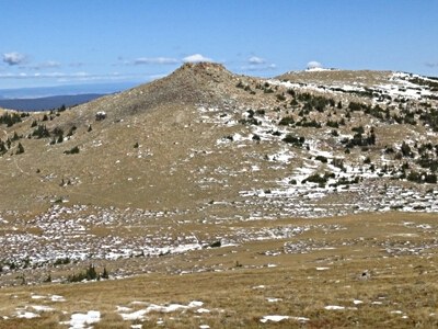
Crown Point
This hike to Crown Point in the Comanche Peak Wilderness is through alpine meadows and scattered forest. At the summit, hikers are rewarded with panoramic vistas across Rocky Mountain National Park and the surrounding wilderness.
The hike to Crown Point in the Comanche Peak Wilderness begins at the Browns Lake Trailhead, accessible via Crown Point Road off Pingree Park Road. The trail ascends to a ridge just west of the Crown Point summit at the boundary of the Comanche Peak Wilderness and the northern edge of the Browns Lake travel zone. From this vantage point, hikers can enjoy panoramic views of the Mummy Range to the south, the Medicine Bow Range to the west, and the Snowy Range in Wyoming to the north. Four miles, 1,000' gain.
For those interested in extending their hike, an optional off-trail detour leads to the site of a 1943 B-17 bomber crash near Stormy Peaks, requiring strong navigation skills and is best suited for experienced hikers.. The crash site is located just off the Flowers Trail, about 2.75 miles east of the Browns Lake Trail junction, and is marked by a monument to the B-17 crash victims. This additional trek adds about 8.5 miles and 1,400' gain.
Please note that the area was affected by the Cameron Peak Fire in 2020, and hikers should be cautious of potential hazards such as falling trees, stump holes, and difficult-to-follow trails in burned areas.
Addition information can be found at: Public_Flowers.pdf
- Suitable Activities: Hiking, Snowshoeing
- Snowshoeing Category: Intermediate
- Seasons: Year-round
- Weather: View weather forecast
- Avalanche Terrain Rating Complex
- Difficulty: Challenging
- 11,403 ft
-
Land Manager:
U.S. Forest Service
Comanche Peak Wilderness Area, Canyon Lakes Ranger District (ARNF)
- Parking Permit Required: USFS Permits & Passes
- Recommended Party Size: 8
- Maximum Party Size: 12
- Maximum Route/Place Capacity: 12
- Trails Illustrated 112
This is a list of titles that represent the variations of trips you can take at this route/place. This includes side trips, extensions and peak combinations. Not seeing a title that fits your trip? Log in and send us updates, images, or resources.
- Crown Point - B-17 Crash Site
There are no resources for this route/place. Log in and send us updates, images, or resources.
