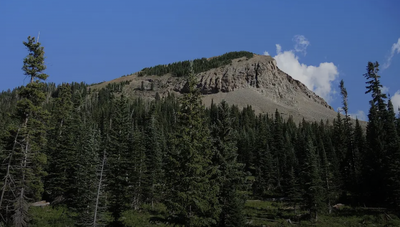
Helmet Peak
Helmet Peak, a scenic outlier in the La Plata Mountains near Mancos, Colorado, is the launch point for a two-and-half mile ridgeline traverse to Rush Basin, a high hidden alpine cirque.
The round trip to Helmet Peak (11,978') summit starts at the "Helmet Peak Parking Platform." (no official name) To get there from Mancos, head north on CO-184. Turn right (east) on County Road 42, which turns into Echo Basin Rd (CR 44). Continue approx 6 mi, then veer right onto FR 566 (gravel). After about 4.5 mi, turn left onto FSR 322 (signed for Helmet Peak/Twin Lakes). Continue about a mile to reach the "parking platform" at approximately 10,960 ft., the high point/pass between the Hogback and Helmet Peak. The road crosses a talus field before reaching the pass. High-clearance or 4WD recommended, especially beyond Transfer Campground. This area is a favorite for ATV's and Off-Road Vehicles.
There are multiple routes up the mountain, this recommended one is direct and safe. Excellent directions, photos, and maps available here. It begins just south of the pass. The mountain lies due east but rock glaciers and spectacular cliffs prohibit a direct approach. Just beyond the parking platform at elevation 10,960 feet, the road does a triple split, Take the leftmost branch thru the talus field.
In 0.1 mile leave the road and head east-southeast up a slope with a constant pitch. Reach the treed saddle, elevation 11,580 feet in 0.7 mile. There is small opening revealing the West Block of the La Platas. The summit is just 0.3 mile off with 400 feet of climbing remaining. Ascent the class 2 south ridge and stay near the top ridge on a social trail. Summit Helmet Peak at one mile. 2.0 miles, 1020' gain.
Alternate Title
Continue on to Rush Basin. The trail includes some talus, light scrambling on the ridge to Rush Basin. Class 2-2+. Total RT 6.8 miles, 2,770' gain.
Simply follow the ridge from Helmet to the northeast. Drop off the summit onto a grassy slope, crossing an old wagon road. The stark and colorful ridge is mostly unobstructed.
To return walk southwest on the irresistible and alluring bench, a tableland that rests between the ridge and the river canyon well below. Look for a wildcat trail at 0.9 mile leading from the bench to the southwest ridge. Retrace your steps over Helmet Peak.
- Suitable Activities: Environmental Awareness, Exploring Nature, Hiking, Scrambling
- Seasons: June, July, August, September, October
- Weather: View weather forecast
- Length: 2.0 mi
- Elevation Gain: 1,020 ft
- 12,201 ft
-
Land Manager:
U.S. Forest Service
Dolores Ranger District (SJNF)
- Parking Permit Required: USFS Permits & Passes
- Recommended Party Size: 8
- Maximum Party Size: 10
- Maximum Route/Place Capacity: 10
- Rampart Hills
- OnX Offroad
- Summit Post
- listsofjohn
This is a list of titles that represent the variations of trips you can take at this route/place. This includes side trips, extensions and peak combinations. Not seeing a title that fits your trip? Log in and send us updates, images, or resources.
- Helmet Peak - Rush Basin
There are no resources for this route/place. Log in and send us updates, images, or resources.
