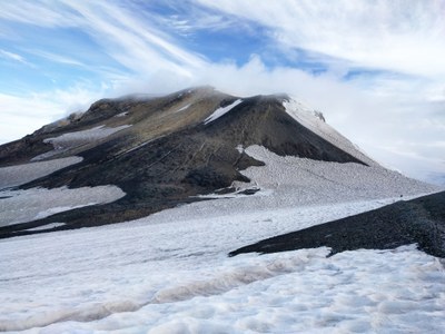
Mount Adams/South Spur
Mount Adams via the South Spur is a strenuous 14 mile snow scramble to the summit of one of Washington's volcanoes, with 6,600 feet of elevation gain, commonly done in two days.
Getting There: From I-5 south take SR 12 east for 48 miles to Randle. Turn south on Forest Road 23 and follow it 56 miles to Trout Lake. From Trout Lake, proceed 0.25 mi to Trout Lake Ranger Station to register climb. Consider carpooling from here. Then travel north from Trout Lake 1 mile to Forest Road 80, then left on Forest Road 8040 and follow it to the Cold Springs Campground and south route trailhead (5,600 ft).
Ascent Route: Follow old road from trail head approximately 1 mi to old timberline campground and junction with Round the Mountain Trail. Continue on trail to crossing at Morrison Creek (below remnants of Crescent Glacier). Cross and continue north then west, continually ascending to ridge line. Up ridge 0.5 mi and 800 ft vertical rise to snowfield above Crescent Glacier. Up snowfield to approximately 9,050 ft and campsite to left of upper snowfield. Here is a good water source. May also camp at Lunch Counter at 9400 ft (with everyone else!)
Travel northeast up to main snowfield on south spur and ascend directly to false summit at 11,657 ft. Continue north-northwest to south side of summit formation, then ascend 30° snow to broad summit area. From here it is 200 yards to lookout and summit.
More information, including Northwest Forest Pass permitting and Land Manager info, can be found here: https://www.mountaineers.org/activities/routes-places/mount-adams-south-spur. Please check scheduled trips listed in the Mountaineers' Activities tab to see if there is another group already booked on the same day. Leaders are expected to contact the leader(s) of existing trips to ensure there are no concerns or conflicts.
- Suitable Activities: Mountaineering
- Climbing Category: Basic Alpine Climb
- Snowshoeing Category: Basic
- Seasons: April, May, June, July, August
- Weather: View weather forecast
- Avalanche Terrain Rating Challenging View avalanche forecast.
- Length: 14.0 None
- Elevation Gain: 6,600 ft
- 12,276 ft
- Land Manager: U.S. Forest Service
- Parking Permit Required: USFS Permits & Passes
- Recommended Party Size: 6
- Maximum Party Size: 12
- Maximum Route/Place Capacity: 12
- USGS Mt Adams West
- USGS Mt Adams East
There are no resources for this route/place. Log in and send us updates, images, or resources.
