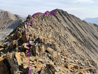
Mt. Blaurock and Ervin Peak
Mt Blaurock – 13,626 & Ervin Peak – 13,538 are two peaks in the Sawatch Mountain Range.
Please read the Collegiate Peaks Wilderness regulations
- Mount Blaurock: 39°00′40″N 106°27′13″W
- Mount Ervin: 39°00′14″N 106°26′19″W
Directions
From Leadville: Drive 20 miles south on U.S. 24 and turn right on the Chaffee County 390 road.
From Buena Vista: Drive 14.5 miles north on U.S. 24 and turn left on the Chaffee County 390 road.
On the 390 road (dirt), drive 11.3 miles to the old town of Winfield. Reach a junction where the main road goes left. Turn right onto the 4WD road signed for the CDT and La Plata Peak trails. Measure from here.
Parallel a fence for a bit before turning left. At 0.4 mile, pass the Winfield Cemetery, which is marked by an explanatory sign. Shortly thereafter, pass a loop to your right, that provides some parking. Continue a bit farther and you'll find a turn-off on the left, with more parking. At 1.8 miles, reach a signed junction. Turn right and park 50 yards up from the turn. This is the parking area for the trailhead. The road above is closed to vehicles and the actual trailhead and start of the trail is 0.1 mile up this narrow road.
- Suitable Activities: Hiking
- Seasons: May, June, July, August, September, October
- Weather: View weather forecast
- Length: 5.0 mi
- Elevation Gain: 3,800 ft
- 13,626 ft
-
Land Manager:
U.S. Forest Service
Collegiate Peaks Wilderness Area, Leadville Ranger District (PSINF)
- Parking Permit Required: USFS Permits & Passes
- Recommended Party Size: 12
- Maximum Party Size: 15
- Maximum Route/Place Capacity: 12
There are no resources for this route/place. Log in and send us updates, images, or resources.
