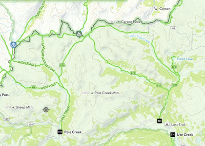
Northwest Pole, Pole Creek Mountain, & Carson
Three Bi-Centennials in the San Juans, Rio Grand National Forest. Recommended as a backpack with basecamp.
Total (APPROX). Mileage (Backpack & 3 peaks): 27.3 miles. Elevation gain (APPROX) : 7,782ft'
Trailhead: Cataract Gulch Trail. Class: 2 - 4.
Cataract Gulch - From Lake City take Highway 149 south for approx. 2 miles. Turn right onto CR 30, (towards Lake San Cristobal). Drive long side the lake to the junction of CR30 & CR35. Turn left on CR 35 toward Sherman Town Site and drive about 1.4 miles. The trailhead which is accessible by car is well marked, on your left.
Cataract Gulch Trail is packed with cascading waterfalls, dense forests, and abundant wildflowers. Cataract Lake is 4.3 miles from the trailhead & approx 2600 ft elevation gain, making a base camp higher than the lake helps avoid backtracking. The summit block of NW Pole depending on the route can vary from class 3 - class 4. The block's east side has less exposure and may involve 2 -3 class 4 moves but the rock is solid. A class 3 may be found across the top of the block.
Descend to the saddle between NW Pole and Pole Creek a drop of about 800ft, first on loose rock then tundra, before heading up to Pole Creek Mountain. Once the access gully is located follow the ridge south towards the summit of Pole Creek. Retrace your route to the saddle between the peaks. Descend to the east to join West Lost Creek Trail before travelling north to a chosen campsite near the CDT.
Carson Pk. can be as little as 3.9 miles and 1400 ft elevation for day two of this peak bagging backpack, depending on choice of base camp. Carson Pk is a class two climb north east of Cataract Lake.
Mill Creek Campground is located 14 miles southwest of Lake City and is approx. 3 miles from the Cataract Gulch TH. It has 22 campsites, limited to eight people and two vehicles per site. Vault restrooms, hand pumps for potable water. Campground hosts are available from June through early September.
- Suitable Activities: Backpacking, Scrambling
- Seasons: July, August, September
- Weather: View weather forecast
- Difficulty: Difficult
- Length: 27.3 mi
- Elevation Gain: 7,782 ft
- 13,716 ft
-
Land Manager:
U.S. Forest Service
Ouray Ranger District (GMUG)
- Parking Permit Required: USFS Permits & Passes
- Recommended Party Size: 8
- Maximum Party Size: 12
- Maximum Route/Place Capacity: 12
There are no resources for this route/place. Log in and send us updates, images, or resources.
