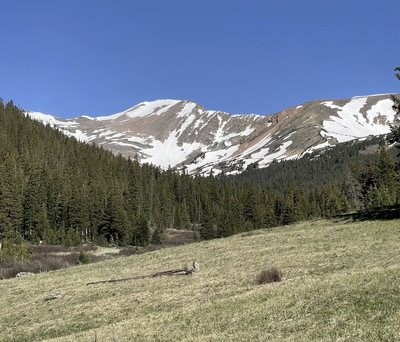
Pettingell Peak
Pettingell Peak is on the Continental Divide and offers a range of scrambling options and a variety of approaches.
Pettingell Peak (13,553') straddles the Continental Divide between Roosevelt National Forest in Clear Creek County and Arapaho National Forest in Grand County, and provides some of the best summit views on the Front Range. It is just high and north enough that it provides a massive panorama including Rocky Mountain National Park, the west side of the Indian Peaks, Grays and Torreys, the Ten Mile Range, the Gore Range, and the Flat Tops. This is a fun scramble, albeit a bit loose in places.
Alternate Titles:
Pettingell Peak via East Ridge - A Class 2 scramble up the side or a Class 3 or 4 scramble on the ridge line to the top - 8.8 miles, 3,400' gain.
Pettingell to The Citadel, Hagar Mountain, and Hassell Peak
Pettingell via Woods, Machebeuf
- Suitable Activities: Backcountry Skiing/Splitboarding, Hiking, Scrambling, Ski Mountaineering
- Seasons: June, July, August, September
- Weather: View weather forecast
- Avalanche Terrain Rating Challenging View avalanche forecast.
- Difficulty: Mod C
- Length: 8.8 mi
- Elevation Gain: 3,400 ft
- 13,559 ft
-
Land Manager:
U.S. Forest Service
Clear Creek Ranger District (ARNF)
- Parking Permit Required: USFS Permits & Passes
- Recommended Party Size: 12
- Maximum Party Size: 12
- Maximum Route/Place Capacity: 12
- 14ers.com
- climb13ers.com
- AllTrails
- AllTrails
This is a list of titles that represent the variations of trips you can take at this route/place. This includes side trips, extensions and peak combinations. Not seeing a title that fits your trip? Log in and send us updates, images, or resources.
- Pettingell Peak - via East Ridge Scramble
- Pettingell Peak - to The Citadel, Hagar Mountain, and Hassell Peak
- Pettingell Peak - via Woods, Machebeuf
There are no resources for this route/place. Log in and send us updates, images, or resources.
