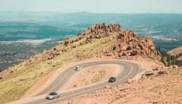
Pikes Peak Highway
The Pikes Peak Highway is a 19-mile toll road that runs from Cascade to the summit of Pikes Peak 14,115,' suitable for 12.5 miles road biking all the way to the top.
Pikes Peak - America's Mountain, in cooperation with the US Forest Service, allows unescorted bicyclists on the Pikes Peak Highway. The highway is fully paved and open year-round, up to the altitude where snow removal becomes excessively difficult.
The ride from Crystal Reservoir Visitor Center (elevation 9,230 ft.) to the Summit (14,115') gains 4,885' in elevation, turns 154 times and is about 12.5 miles long one way. Be sure to give yourself plenty of time to descend before it gets dark.
Be aware there is vehicular traffic and often some construction on the Highway with no physical separation for bicyclists. Be prepared for rapidly changing weather conditions.
Riders planning to drive to the highway and then bike to the summit are encouraged to park at the Visitors Center parking lot. Riders must follow all safety and traffic rules, use regulations and hours of operation. Riders under age 18 must be escorted by a parent or legal guardian.
Participants are required to pay the regular admission fee ($15 in 2024) or use one of the Pikes Peak-America’s Mountain passes. Annual and group passes available. Neither National Park Passes nor North Slope fees and passes are eligible for cycling Pikes Peak.
Because conditions change frequently, it is recommended to call the pre-recorded information line, 719-385-7325, updated approximately 30 minutes prior to opening and then as conditions change throughout the day.
- Suitable Activities: Biking
- Seasons: Year-round
- Weather: View weather forecast
- Difficulty: Difficult
- Length: 25.0 mi
- Elevation Gain: 4,885 ft
- 14,115 ft
-
Land Manager:
U.S. Forest Service
Pikes Peak Ranger District (PSINF)
- Parking Permit Required: USFS Permits & Passes
- Recommended Party Size: 12
- Maximum Party Size: 12
- Maximum Route/Place Capacity: 12
There are no resources for this route/place. Log in and send us updates, images, or resources.
