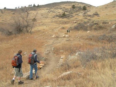
Reservoir Ridge
The Fort Collins Natural Area is a 300+ acre in-town natural area managed by the City of Fort Collins with about 5 miles of soft-surface trail connecting to other local trail systems including the Foothills Trail to the Maxwell and Pineridge Natural Areas.
For further information and any restrictions see: Recreation - City of Fort Collins (fcgov.com)
Directions to trailhead: Reservoir Ridge North Loop Trail Head - Google Maps
N Overland Trail - Google Maps
Alternate title data:
Reservoir Ridge (Fort Collins Natural Area)
Vegetation consists of grassland, ponderosa pine stands, and foothills shrubland providing habitat for wildlife including eagles and other raptors. The ridge offers views of Horsetooth Reservoir and Lory State Park to the west, and the city to the east. There are three trailheads, the Overland Trail Road trailhead is easily accessible from town by bike.
To review the Trip Leader Checklist see: Shared R:P+Trip Leader Activity Checklists - Google Docs
- Suitable Activities: Biking, Exploring Nature, Family, Hiking, Trail Running
- Seasons: Year-round
- Weather: View weather forecast
- Difficulty: Easy
- Length: 5.8 mi
- Elevation Gain: 656 ft
- 5,650 ft
- Land Manager: Fort Collins
- Parking Permit Required: Other
- Recommended Party Size: 8
- Maximum Party Size: 12
- Maximum Route/Place Capacity: 12
This is a list of titles that represent the variations of trips you can take at this route/place. This includes side trips, extensions and peak combinations. Not seeing a title that fits your trip? Log in and send us updates, images, or resources.
- Reservoir Ridge (Fort Collins Natural Area)
There are no resources for this route/place. Log in and send us updates, images, or resources.
