RMNP - Longs Peak TH
This is the most common route for Longs Peak, part of Rocky Mountain National Park. The route climbs steadily through the forest but the views open up dramatically once above treeline.
Please view this document with everything you need to know about Rocky Mountain National Park
Before creating a trip, click “Activities” below to make sure there isn’t already a trip booked to the same place on the same date.
For further information and any restrictions see: Longs Peak - Keyhole Route - Rocky Mountain National Park (U.S. National Park Service) (nps.gov)
Rules & Regulations - Rocky Mountain National Park (U.S. National Park Service) (nps.gov)
Here is the link to the closure areas, updated year-round: Area Closures to Protect Plants & Animals - Rocky Mountain National Park (U.S. National Park Service) (nps.gov)
Directions to trailhead: East Longs Peak Trail – Longs Peak Trail – Keyhole Route – Shelf Trail - Google Maps
Alternate title data:
The Boulder Field
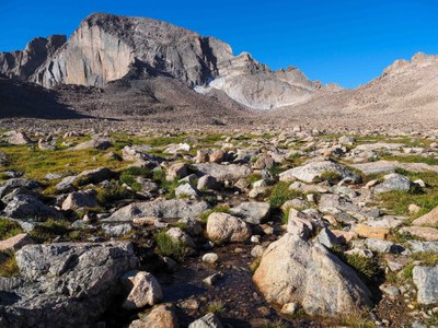
The Boulder Field is, as its name describes, a sea of rocks. It is in a flat valley surrounded by Mount Lady Washington, Storm Peak, and the North Face of Longs Peak. Our destination is the Boulder Field campground. Summiteers have the option of overnighting here just to make the summit day shorter. There are vault toilets at the Boulder Field.
The Keyhole
The Keyhole is a uniquely shaped gap in a ridge at the far end of the Boulder Field. The views into the Glacier Gorge on the western side of the ridge are spectacular. The trail to the Longs Peak summit goes through this gap.
Once past the Boulder Field Campground, the "trail" ends and the route becomes delineated by large cairns. It's a rock-hop up to the Keyhole. Approaching the gap, we'll pass by the Agnes Vaille Shelter - a memorial of sorts to a fallen CMCer.
Chasm View
From Chasm View, Chasm Lake is far below, and the vertical Diamond Face of Longs is right in front of you.
Battle Mountain Loop
Mills Glacier: 10 miles, 3,100 ft elevation gain
Take the standard trail system to Chasm Lake. Looking across the lake, you will see the large snowfields beneath the east face of Longs Peak. This is (was) the Mills Glacier. Getting there in summer is an arduous boulder-hop. In winter, however, you just cross the frozen lake.
This route is best suited for travel in the early spring (May or early June). Chasm Lake will still be frozen. Snowshoes will be required above Chasm Lake but likely not needed at all on the approach. Spikes should suffice.
Mount Lady Washington: 8 miles, 3,800 ft elevation gain
A sub-peak of Long's Peak, this summit offers great views of Long Peak just above chasm lake. This hike follows the Long's Peak trail to the Chasm Lake junction, then goes straight up to the summit.
Storm Peak:
A sub-peak of Long's Peak located just north of the Keyhole. The trail follows the Long's Peak trail to the Boulder Field and then you leave the trail at the Boulder Field and rock-hop/scramble due west up the gentle slopes to the summit.
Estes Cone: 6.2 miles, 1,938 ft elevation gain
The summit of Estes Cone trail offers some of the best views found in the area. You'll begin by parking at the Longs Peak Trailhead and hiking the first section of the Longs Peak Trail for a short distance before turning onto the Eugenia Mine Trail.
- Suitable Activities: Backpacking, Climbing, Hiking, Scrambling, Snowshoeing
- Snowshoeing Category: Intermediate
- Seasons: Year-round
- Weather: View weather forecast
-
Land Manager:
National Park Service
Rocky Mountain National Park
- Parking Permit Required: National Park Entrance Fees
- Recommended Party Size: 12
- Maximum Party Size: 24
- Maximum Route/Place Capacity: 24
This is a list of titles that represent the variations of trips you can take at this route/place. This includes side trips, extensions and peak combinations. Not seeing a title that fits your trip? Log in and send us updates, images, or resources.
- RMNP - Longs Peak TH - The Boulder Field
- RMNP - Longs Peak TH - The Keyhole
- RMNP - Longs Peak TH - Chasm View
- RMNP - Longs Peak TH - Battle Mountain Loop
- RMNP - Longs Peak TH - Mills Glacier
- RMNP - Longs Peak TH - Mount Lady Washington
- RMNP - Longs Peak TH - Storm Peak
- RMNP - Long Peak TH - Estes Cone
There are no resources for this route/place. Log in and send us updates, images, or resources.
