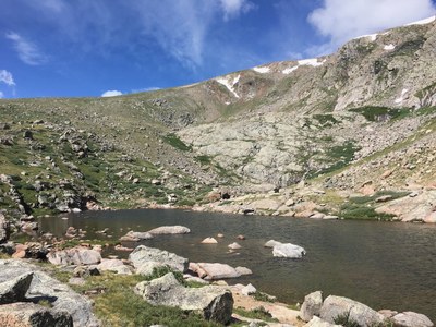
Roosevelt Lakes
Nestled below Rosalie Peak in the Mt Evans Wilderness, Roosevelt Lakes is a 9.7 mile out and back trip with 2,870'of elevation gain. The route is mostly forested transitioning to above tree line, passing by streams, Bristlecone pines, and nearby Pegmatite Points.
Beginning at the Deer Creek Trailhead at elev. 9248 ft, ascend gradually through a shaded and forested area along the Tanglewood Trail (USFS #636) and Tanglewood Creek. The route steepens around mile 3, ascending switchbacks and breaking out of tree line at elev. 11,400 ft. Ascend to the saddle between Rosalie Peak and Pegmatite Points at elev. 11,965 ft. with views of Royal Mountain, Bandit Peak and the flanks of Rosalie Peak elev. 13,565 ft. Continue North along the Roosevelt Lakes Trail (USFS #56) across alpine terrain towards Beartrack Lakes, reaching Roosevelt Lakes at mile 4.8 elev. 11,750 ft. An optional short side-trip to Pegmatite Points can be done on the way in or out from the saddle, depending on conditions.
- Suitable Activities: Hiking
- Seasons: June, July, August, September, October
- Weather: View weather forecast
- Difficulty: Easy C
- Length: 9.7 mi
- Elevation Gain: 2,870 ft
- 11,965 ft
-
Land Manager:
U.S. Forest Service
Mount Evans Wilderness Area, South Platte Ranger District (PSINF)
- Parking Permit Required: USFS Permits & Passes
- Recommended Party Size: 12
- Maximum Party Size: 12
- Maximum Route/Place Capacity: 12
- https://caltopo.com/m/7SPAQ
- AllTrails
This is a list of titles that represent the variations of trips you can take at this route/place. This includes side trips, extensions and peak combinations. Not seeing a title that fits your trip? Log in and send us updates, images, or resources.
- Tanglewood Trail
- Roosevelt Lakes Trail
- Rosalie Peak
There are no resources for this route/place. Log in and send us updates, images, or resources.
