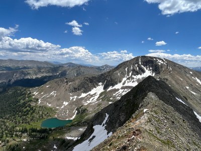
Savage Peak
Savage Peak sits at 13,135' (Lidar) in the Sawatch range overlooking the Missouri Lakes below. Savage Peak rests in the Holy Cross Wilderness within the White River National Forest.
Savage Peak is often accessed utilizing the Missouri Lakes trail and trailhead. This is a very popular trailhead, as the Missouri Lakes trail and Fancy Lake trail share the same parking area. Being not far from Vail, these two trails see heavy usage. While the approach trail is very busy, the summit is very lightly trafficked.
There are two common ascents:
- ENE Ridge - ascent begins along this Missouri Lake trail until a very pronounced avalanche path approximately just over 2 miles up the trail. A little bushwhacking will take the hiker to a grassy slope to gain the ridge. The ridge walk is very straightforward, with the peak coming into view rather quickly. The last bit ascending the summit is rather steep but has good footing. This is a class 2 hike. Hikers often do this route as an out-and-back. The avalanche path is pretty close to the lakes as well so a visit up to the lakes would be easy enough to add on to a summit. Out and back is approximately 8 miles RT and 3,500 feet of cumulative elevation gain.
- Gully approach - Continue to the lakes and past Savage Peak. There is a shallow gully that can be ascended (39.38777, -106.52391) that reaches a saddle at approximately 12,500'. This gully contains loose dirt and rock and is likely a better ascent route than descent route and preferable with snow coverage. It also can make a good point to bail on a ridge traverse if weather were to move in. Once at the saddle, the terrain is a class 2 ridge. The summit is obvious so continue along the ridge to the summit. Many hikers choose to descend the ENE ridge.
As an extra option, the entire ridge is traversable, beginning with an ascent of the ENE ridge and continuing to Missouri Pass. Maintaining the ridge proper yields a class 3 scramble. Every tower can be circumvented lowering the classification to 2 if desired. Eventually the ridge become a wide, grassy area. The descent is down to Missouri Pass. The descent itself poses two options at a gully. To the right (east) appears to be class 4 down climbing. To the left (west of the gully) is class 2 on solid talus. Bearing east once down the steep descent will bring hikers to Missouri Pass. Well into July, small snowfields will remain after the descent while approaching the pass, easily crossable with microspikes.
- Suitable Activities: Backpacking, Scrambling, Backcountry Skiing/Splitboarding
- Seasons: Year-round, May, June, July, August, September, October
- Weather: View weather forecast
- 13,135 ft
-
Land Manager:
U.S. Forest Service
Holy Cross Wilderness Area, Holy Cross Ranger District (WRNF)
- Parking Permit Required: USFS Permits & Passes
- Recommended Party Size: 7
- Maximum Party Size: 15
- Maximum Route/Place Capacity: 15
- https://caltopo.com/m/6HD3
- https://www.climb13ers.com/colorado-13ers/savage-peak
- https://www.fs.usda.gov/r02/whiteriver/alerts/holy-cross-wilderness-prohibitions
There are no resources for this route/place. Log in and send us updates, images, or resources.
