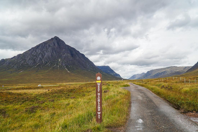
Scotland - West Highland Way
The West Highland Way is a linear long distance footpath in Scotland, with the official status of Long Distance Route (LDR). It is 154.5 km (96.0 miles) long, extending from Milngavie north of Glasgow to Fort William in the Scottish Highlands, with an element of hill hiking on the route.
The path uses many ancient roads, including ancient drovers' roads, military roads dating to the Jacobite uprisings, and old coaching routes. It is traditionally done from south to north.
The path officially starts in Milngavie town centre, where a granite obelisk is located. It proceeds by way of country roads, an abandoned railway, the Queen Elizabeth Forest Park and scenic Conic Hill in the Highland Boundary Fault, to reach Balmaha on Loch Lomond. From here, the route follows the isolated, wooded, eastern shores of the loch via Rowardennan and Inversnaid to Inverarnan.
The Way follows Glen Falloch northward to Crianlarich then northwest along Strathfillan to Tyndrum. North of Tyndrum the Way enters Glen Orchy before crossing the desolate yet beautiful Rannoch Moor and descending into Glen Coe. From here, the route climbs the Devil's Staircase before a great descent to sea level at Kinlochleven.
The final stage skirts the Mamore Mountains on an old military road and descends into Glen Nevis before finishing in Fort William. The last stage passes the foot of Ben Nevis and many crown their achievement of hiking the Way by climbing it, the highest mountain in the United Kingdom.
- Suitable Activities: Backpacking, Biking, Hiking
- Seasons: Year-round
- Weather: View weather forecast
- Length: 96.6 mi
- Elevation Gain: 8,327 ft
- 1,750 ft
- Land Manager: Land Manager Varies
- Parking Permit Required: Other
- Recommended Party Size: 12
- Maximum Party Size: 12
- Maximum Route/Place Capacity: 12
There are no resources for this route/place. Log in and send us updates, images, or resources.
