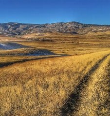
Sharptail Ridge Open Space
This trail is located in Sharptail Ridge Open Space in Douglas County. Beautiful views of the front range and Roxbough State Park.
For further information and any restrictions see: Sharptail Ridge Open Space and Trail - Douglas County
Directions to parking lot: Sharptail Ridge Open Space - Google Maps
Alternate Titles
Sharptail Trail - 8.3 miles, 882 elevation gain
This area is a regionally significant movement-corridor for wildlife – so good for viewing elk, deer, wild cats, and ground-nesting birds. It is a meadow hike, fully exposed to sun so keep that in mind when scheduling a trip. Bikes and dogs are not allowed. Because it is an SWA, every hiker must have a state hunting or fishing license, or an SWA Pass.
The fall hunting season varies year-to-year so call the State Hunt Line at 303-297-1192 to confirm closure dates.
- Suitable Activities: Hiking
- Seasons: Year-round
- Weather: View weather forecast
- Land Manager: Douglas County Open Space
- Parking Permit Required: Other
- Recommended Party Size: 10
- Maximum Party Size: 12
- Maximum Route/Place Capacity: 12
This is a list of titles that represent the variations of trips you can take at this route/place. This includes side trips, extensions and peak combinations. Not seeing a title that fits your trip? Log in and send us updates, images, or resources.
- Sharptail Ridge Open Space - Sharptail Trail
There are no resources for this route/place. Log in and send us updates, images, or resources.
