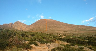
Storm Peak
https://www.14ers.com/route.php?route=201308012056566208
Storm Peak (13,277 feet) has a well-maintained class-1 trail exists to within a quarter mile of its summit followed by an easy class-2 scramble.
The trailhead is west of Colorado 7 and can be reached from the north or the south. For the northern approach, drive 9.2 miles south from the intersection of US 36 and CO 7 to the turnoff for the Ranger Station. For the southern approach, drive north 10 miles from the junction of CO 7 and CO 72 on the Peak to Peak Highway to the Ranger Station turnoff. From the turnoff drive west 1 mile to the trailhead.
Note: Car-camping is not allowed in the parking area. There is a tent campground nearby and a couple of full campgrounds near Meeker Park. If camping at a NPS regulated site, bear cannisters are now required.
- Suitable Activities: Hiking, Scrambling
- Seasons: Year-round
- Weather: View weather forecast
- View avalanche forecast.
- Length: 12.0 mi
- Elevation Gain: 4,100 ft
- 13,277 ft
-
Land Manager:
National Park Service
Pikes Peak Ranger District (PSINF)
- Parking Permit Required: National Park Entrance Fees
- Recommended Party Size: 6
- Maximum Party Size: 12
- Maximum Route/Place Capacity: 12
There are no resources for this route/place. Log in and send us updates, images, or resources.
