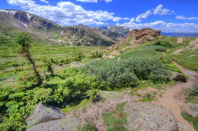
Stormy Peaks
This trail is located near Bellvue, CO with an elevation gain of 3,477 ft and total mileage of 12.1 miles.
Alternate Titles
- Stormy Peaks-1943 B-17 Crash Site
Generally considered a challenging route. This is a popular trail for birding and hiking, but you can still enjoy some solitude during quieter times of day. The best times to visit this trail are April through November. You'll need to leave pups at home — dogs aren't allowed on this trail.
The trail follows a moraine for more than a mile and then begins rising to provide spectacular views of Pingree Park and the Mummy Range. The trail crosses almost a mile of the Comanche Peak Wilderness before reaching the northern border of Rocky Mountain National Park.
Stormy peak trail information
The trail crosses into both USFS and RMNP areas. Please read the regulations and information associated with both RMNP and Comanche Peak wilderness.
- Suitable Activities: Hiking
- Seasons: April, May, June, July, August, September, October, November
- Weather: View weather forecast
- Difficulty: Moderate
- Length: 12.1 mi
- Elevation Gain: 3,477 ft
- 12,113 ft
-
Land Manager:
Land Manager Varies
Comanche Peak Wilderness Area
- Parking Permit Required: Other
- Recommended Party Size: 12
- Maximum Party Size: 12
- Maximum Route/Place Capacity: 12
This is a list of titles that represent the variations of trips you can take at this route/place. This includes side trips, extensions and peak combinations. Not seeing a title that fits your trip? Log in and send us updates, images, or resources.
- Stormy Peaks-1943 B-17 Crash Site
There are no resources for this route/place. Log in and send us updates, images, or resources.
